
Wêne:Map Anatolia ancient regions-en.svg

Dosyeya orjînal (Daneya SVG, mezinbûna rast: 921 × 596 pixel; mezinbûna daneyê: 256 KB)
| Ev pel ji Wikimedia Commonsê ye. Agahdariya li ser rûpela danasîna pelê li jêr tê nîşandan. |
| Danasîn |
Català: Mapa regional d'Àsia Menor al segle II aC
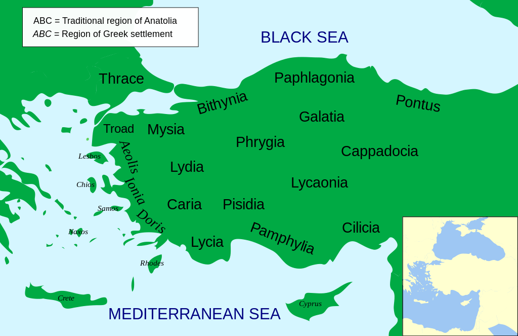
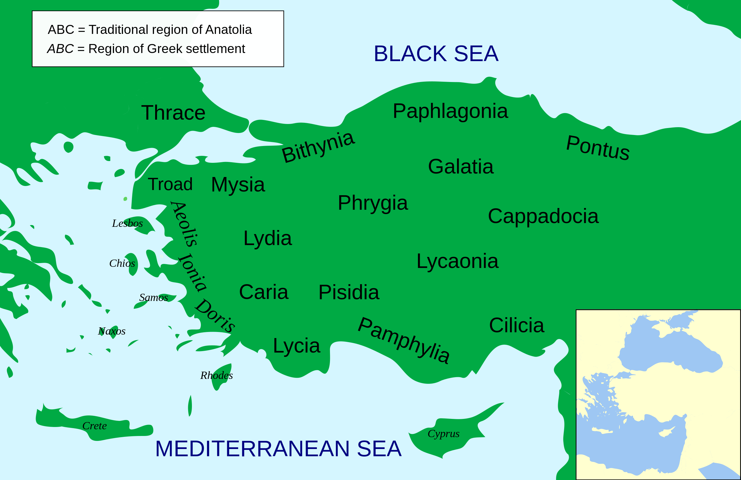
English: Regional map of Asia Minor in the 2nd Century BC |
| Dîrok | (UTC) |
| Çavkanî | |
| Xwedî |
|
| Guhartoyên din |
Other related versions: []
Derivative works of this file: |


.svg)


|
This SVG file contains embedded text that can be translated into your language, using any capable SVG editor, text editor or the SVG Translate tool. For more information see: About translating SVG files. |
This file is translated using SVG <switch> elements. All translations are stored in the same file! Learn more.
For most Wikipedia projects, you can embed the file normally (without a To translate the text into your language, you can use the SVG Translate tool. Alternatively, you can download the file to your computer, add your translations using whatever software you're familiar with, and re-upload it with the same name. You will find help in Graphics Lab if you're not sure how to do this. |
| Ew wêneyekî guhertî ye, li ser wêneyê orjînal guhertin hatiye çêkirin û ev pêk hatiye. Guhertinên hatine çêkirin: Increased legibility, slight corrections in position.Tu dikarî li Asia Minor Political 500BC.svg wêneyê orjînal bibînî. Guhertinên wêne ji aliyê MinisterForBadTimes ve hatine çêkirin.
|
- Tu azad î:
- parve bike – ji bo kopîkirin, belavkirin û weşandina xebatê
- ji bo guhartin û adaptekirina naverokê – ji bo adaptekirina xebatê
- Di bin van mercan de:
- isnad – Divê tu isnadeke maqûl bikî, lînekek pêşkêş bikî ji bo lîsansê, û diyar bikî ku guhartin hatiye kirin an na. Tu dikarî vê yekê bi adilî bi cih bînî, lê ne bi awayê ku wekî lîsansor te an bikaranîna te pejirandibe.
- parvekirinê mîna hev – Ger tu materyalê biguherînî, bizivirînî formeke din, an ava bikî divê beşdariyên xwe di bin eynî lîsansê an lîsansa hevaheng de wekî ya eslî belav bikî.

|
Ev dosye di bin Lîsansa Belgekirina Azad a GNU hate barkirin.
Kopîkirin, belavkirin û guhartin di bin qebûlkirinên lîsansa GNU de ye, versiyona 1.2 versiyoneke kevintirîn a belavkirinê ya ji bo Weqfa Nivîsbara Azad, tê qebûlkirin. Kopyeyek lîsanse di beşa bi sernavê Lîsansa Belgekirina Azad a GNUde cî digre. |
Original upload log
This image is a derivative work of the following images:
- File:Asia_Minor_Political_500BC.svg licensed with Cc-by-sa-3.0, GFDL
- 2009-04-22T07:38:42Z MinisterForBadTimes 921x596 (283615 Bytes) Coloured in rogue region
- 2009-04-22T07:36:20Z MinisterForBadTimes 921x596 (283353 Bytes) Changed fonts...again
- 2009-04-22T07:33:39Z MinisterForBadTimes 921x596 (283414 Bytes) Changed fonts
- 2009-04-22T07:25:50Z MinisterForBadTimes 921x596 (284262 Bytes) {{Information |Description={{en|1= Political map of Asia Minor in 500 BC}} |Source=*[[:File:Mysia.svg|]] |Date=2009-04-22 08:23 (UTC) |Author=*[[:File:Mysia.svg|]]: [[User:Emok|Emok]] *derivative work: *[[:Image:Mysia_map_anc
Uploaded with derivativeFX
Dîroka daneyê
Ji bo dîtina guhartoya wê demê bişkoka dîrokê bitikîne.
| Dîrok/Katjimêr | Wêneyê biçûk | Mezinahî | Bikarhêner | Şirove | |
|---|---|---|---|---|---|
| niha | 14:14, 15 sibat 2024 | | 921 x 596 (256 KB) | Manlleus | File uploaded using svgtranslate tool (https://svgtranslate.toolforge.org/). Added translation for ca. |
| 14:01, 15 sibat 2024 |  | 921 x 596 (235 KB) | Manlleus | fixed text labels for translation | |
| 19:48, 23 nîsan 2009 |  | 921 x 596 (278 KB) | MinisterForBadTimes | Added Galatia, minor other changes | |
| 16:01, 22 nîsan 2009 |  | 921 x 596 (277 KB) | MinisterForBadTimes | {{Information |Description={{en|1= Political map of Asia Minor in 500 BC}} |Source=*File:Asia_Minor_Political_500BC.svg |Date=2009-04-22 17:00 (UTC) |Author=*File:Asia_Minor_Political_500BC.svg: *Mysia.svg: [[User:Emok|Emok |
Bikaranîna pelê
Ev rûpelên li jêr vê dosyeyê bi kar tînin:
Bikaranîna gerdûnî ya pelê
Ev wîkiyên di rêzê de vê pelê bi kar tînin:
- Bikaranîna di af.wikipedia.org de
- Bikaranîna di als.wikipedia.org de
- Bikaranîna di am.wikipedia.org de
- Bikaranîna di ar.wikipedia.org de
- Bikaranîna di azb.wikipedia.org de
- Bikaranîna di az.wikipedia.org de
- Bikaranîna di be-tarask.wikipedia.org de
- Bikaranîna di bg.wikipedia.org de
- Bikaranîna di bn.wikipedia.org de
- Bikaranîna di br.wikipedia.org de
- Bikaranîna di bs.wikipedia.org de
- Bikaranîna di ca.wikipedia.org de
- Bikaranîna di cs.wikipedia.org de
- Bikaranîna di da.wikipedia.org de
- Bikaranîna di de.wikipedia.org de
- Bikaranîna di diq.wikipedia.org de
- Bikaranîna di en.wikipedia.org de
Zêdetir bikaranîna global a vê pelê bibîne.