
Wêne:Carte cameroun francais.gif
Versyonekî jê mezintir tune.
Carte_cameroun_francais.gif (330 × 355 pixel, mezinbûnê data: 11 KB, MIME-typ: image/gif)
| Ev pel ji Wikimedia Commonsê ye. Agahdariya li ser rûpela danasîna pelê li jêr tê nîşandan. |
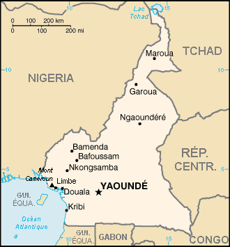
Danasîn
Author : TL
French translation of the WFB's map.
Lîsans
This image is in the public domain because it contains materials that originally came from the United States Central Intelligence Agency's World Factbook.
|
 |
| I, the copyright holder of this work, release this work into the public domain. This applies worldwide. In some countries this may not be legally possible; if so: I grant anyone the right to use this work for any purpose, without any conditions, unless such conditions are required by law. |
Dîroka daneyê
Ji bo dîtina guhartoya wê demê bişkoka dîrokê bitikîne.
| Dîrok/Katjimêr | Wêneyê biçûk | Mezinahî | Bikarhêner | Şirove | |
|---|---|---|---|---|---|
| niha | 14:14, 17 hezîran 2006 | | 330 x 355 (11 KB) | Sting | "équa." + "Rép." corrections |
| 19:50, 2 adar 2006 |  | 330 x 355 (10 KB) | TL | Author : TL French translation of the WFB's map. |
Bikaranîna pelê
Ev rûpelên li jêr vê dosyeyê bi kar tînin:
Bikaranîna gerdûnî ya pelê
Ev wîkiyên di rêzê de vê pelê bi kar tînin:
- Bikaranîna di fr.wikipedia.org de
- Bikaranîna di fr.wikinews.org de
- Bikaranîna di kab.wikipedia.org de
- Bikaranîna di la.wikipedia.org de
- Bikaranîna di mg.wikipedia.org de
- Bikaranîna di pl.wikinews.org de