
Wêne:Europe in 1470.PNG

Mezinahiya vê pêşdîtinê: 553 × 599 pîksel. Resolusyonên din: 221 × 240 pîksel | 600 × 650 pîksel.
Dosyeya orjînal (600 × 650 pixel, mezinbûnê data: 46 KB, MIME-typ: image/png)
| Ev pel ji Wikimedia Commonsê ye. Agahdariya li ser rûpela danasîna pelê li jêr tê nîşandan. |
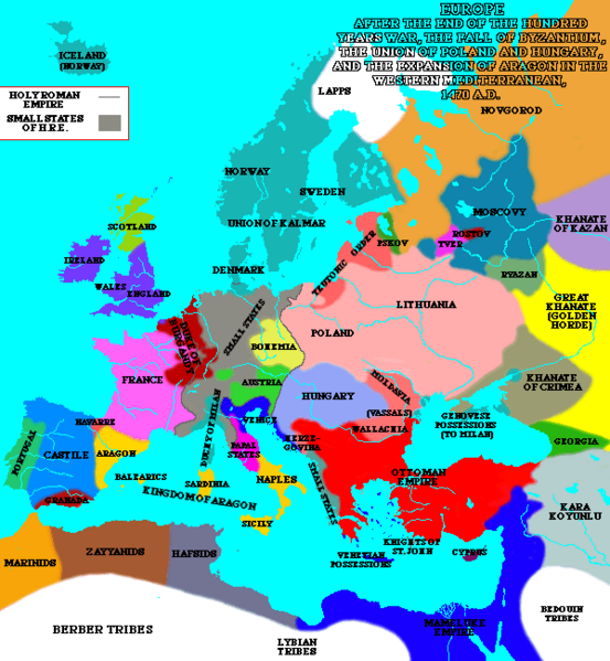
A map of Europe in 1470.
| This work has been released into the public domain by its author, Lynn H. Nelson. This applies worldwide. In some countries this may not be legally possible; if so: Lynn H. Nelson grants anyone the right to use this work for any purpose, without any conditions, unless such conditions are required by law.
|
Source:[1]
_en.png)
.png)
.jpg)
Dîroka daneyê
Ji bo dîtina guhartoya wê demê bişkoka dîrokê bitikîne.
| Dîrok/Katjimêr | Wêneyê biçûk | Mezinahî | Bikarhêner | Şirove | |
|---|---|---|---|---|---|
| niha | 21:35, 19 kanûna paşîn 2024 | | 600 x 650 (46 KB) | Enyavar | Reverted to version as of 19:31, 8 March 2005 (UTC) --> file had been altered by another user |
| 13:15, 7 gulan 2008 |  | 600 x 650 (77 KB) | Fz22~commonswiki | {{Information |Description= |Source= |Date= |Author= |Permission= |other_versions= }} | |
| 19:31, 8 adar 2005 |  | 600 x 650 (46 KB) | Quadell | A map of Europe in 1470.{{PD}}Source:[http://www.ku.edu/kansas/medieval/108/lectures/]Category:Maps of EuropeCategory:Historical mapsCategory:1470 |
Bikaranîna pelê
Ev rûpelên li jêr vê dosyeyê bi kar tînin:
Bikaranîna gerdûnî ya pelê
Ev wîkiyên di rêzê de vê pelê bi kar tînin:
- Bikaranîna di bs.wikipedia.org de
- Bikaranîna di ca.wikipedia.org de
- Bikaranîna di cv.wikipedia.org de
- Bikaranîna di en.wikipedia.org de
- Bikaranîna di es.wikipedia.org de
- Bikaranîna di et.wikipedia.org de
- Bikaranîna di fa.wikipedia.org de
- Bikaranîna di fi.wikipedia.org de
- Bikaranîna di fr.wikipedia.org de
- Bikaranîna di he.wikipedia.org de
- Bikaranîna di id.wikipedia.org de
- Bikaranîna di io.wikipedia.org de
- Bikaranîna di it.wikipedia.org de
- Bikaranîna di mk.wikipedia.org de
- Bikaranîna di no.wikipedia.org de
- Bikaranîna di scn.wikipedia.org de
- Bikaranîna di sh.wikipedia.org de
- Bikaranîna di sl.wikipedia.org de
- Bikaranîna di th.wikipedia.org de