
Wêne:Gz-map.gif
Versyonekî jê mezintir tune.
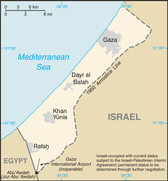
Gz-map.gif (330 × 354 pixel, mezinbûnê data: 14 KB, MIME-typ: image/gif)
| Ev pel ji Wikimedia Commonsê ye. Agahdariya li ser rûpela danasîna pelê li jêr tê nîşandan. |
Updated version of previous file, copied from the CIA World Factbook from this page:
- https://www.cia.gov/library/publications/the-world-factbook/geos/gz.html archive copy at the Wayback Machine
This image is in the public domain because it contains materials that originally came from the United States Central Intelligence Agency's World Factbook.
|
 |
derivative works
Derivative works of this file: Gaza Strip 2011-01-20.gif
Dîroka daneyê
Ji bo dîtina guhartoya wê demê bişkoka dîrokê bitikîne.
| Dîrok/Katjimêr | Wêneyê biçûk | Mezinahî | Bikarhêner | Şirove | |
|---|---|---|---|---|---|
| niha | 14:18, 27 kanûna paşîn 2008 | | 330 x 354 (14 KB) | Timeshifter | Taken from CIA.gov map page for Gaza Strip: "This page was last updated on 24 January, 2008" |
| 01:58, 27 kanûna paşîn 2008 |  | 330 x 354 (13 KB) | Koavf | Removed inaccurate notice about Israeli occupation. | |
| 14:08, 2 kanûna pêşîn 2007 |  | 330 x 354 (14 KB) | Timeshifter | Nov. 15 2007 update of CIA.gov map page for Gaza Strip. | |
| 18:09, 15 tebax 2005 |  | 328 x 352 (9 KB) | Mrmiscellanious~commonswiki | Updated version of previous file, copied from CIA World Factbook on August 15, 2005. |
Bikaranîna pelê
Ev rûpelên li jêr vê dosyeyê bi kar tînin:
Bikaranîna gerdûnî ya pelê
Ev wîkiyên di rêzê de vê pelê bi kar tînin:
- Bikaranîna di ang.wikipedia.org de
- Bikaranîna di ar.wikipedia.org de
- Bikaranîna di arz.wikipedia.org de
- Bikaranîna di ast.wikipedia.org de
- Bikaranîna di ba.wikipedia.org de
- Bikaranîna di ca.wikipedia.org de
- Bikaranîna di diq.wikipedia.org de
- Bikaranîna di el.wikipedia.org de
- Bikaranîna di en.wikinews.org de
- Bikaranîna di eo.wikipedia.org de
- Bikaranîna di eu.wikipedia.org de
- Bikaranîna di fi.wikipedia.org de
- Bikaranîna di ga.wikipedia.org de
- Bikaranîna di gl.wikipedia.org de
- Bikaranîna di hu.wikipedia.org de
- Bikaranîna di la.wikipedia.org de
- Bikaranîna di mt.wikipedia.org de
- Bikaranîna di pt.wikinews.org de
- Bikaranîna di ro.wikipedia.org de
- Bikaranîna di sl.wikipedia.org de
- Bikaranîna di sv.wikipedia.org de
- Bikaranîna di ta.wikipedia.org de
- Bikaranîna di tr.wikinews.org de
- Bikaranîna di tt.wikipedia.org de
- Bikaranîna di uk.wikipedia.org de
- Bikaranîna di ur.wikipedia.org de
- Bikaranîna di vi.wikipedia.org de
- Bikaranîna di www.wikidata.org de