
Wêne:Map provinces Netherlands-en.svg

Size of this PNG preview of this SVG file: 506 × 600 pîksel. Resolusyonên din: 202 × 240 pîksel | 405 × 480 pîksel | 648 × 768 pîksel | 864 × 1024 pîksel | 1727 × 2048 pîksel | 743 × 881 pîksel.
Dosyeya orjînal (Daneya SVG, mezinbûna rast: 743 × 881 pixel; mezinbûna daneyê: 1003 KB)
| Ev pel ji Wikimedia Commonsê ye. Agahdariya li ser rûpela danasîna pelê li jêr tê nîşandan. |
This W3C-unspecified vector image was created with Inkscape .

|
This SVG file contains embedded text that can be translated into your language, using any capable SVG editor, text editor or the SVG Translate tool. For more information see: About translating SVG files. |
Danasîn
| Danasîn |
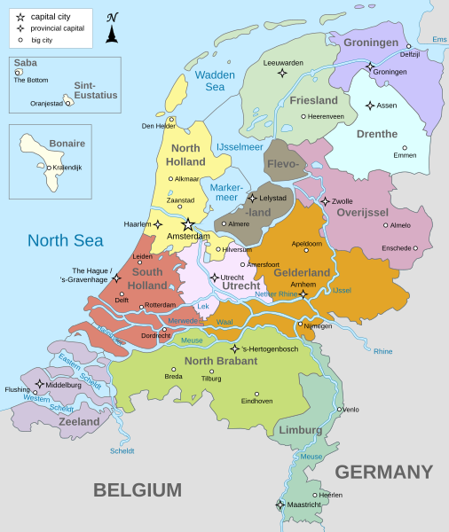
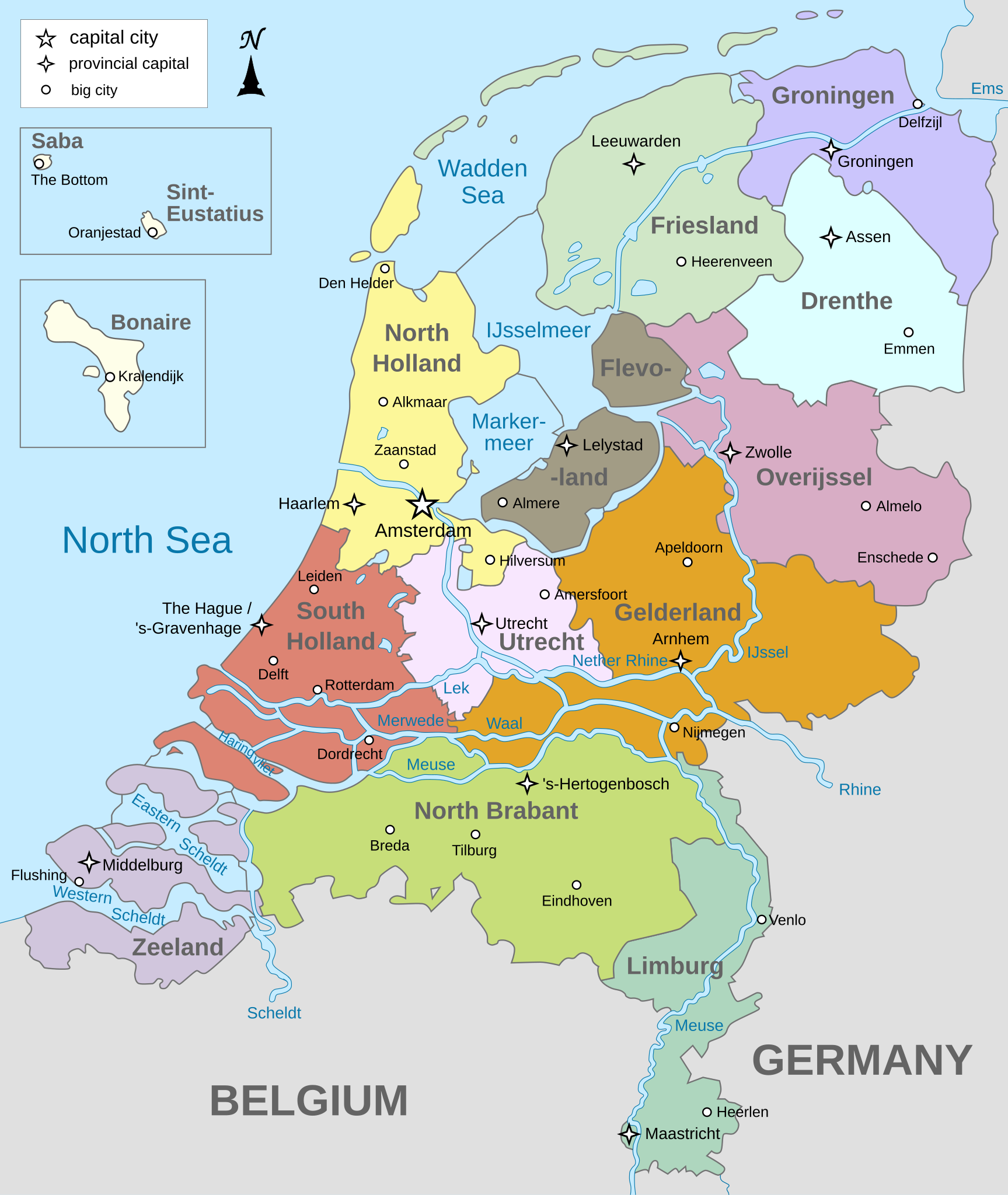
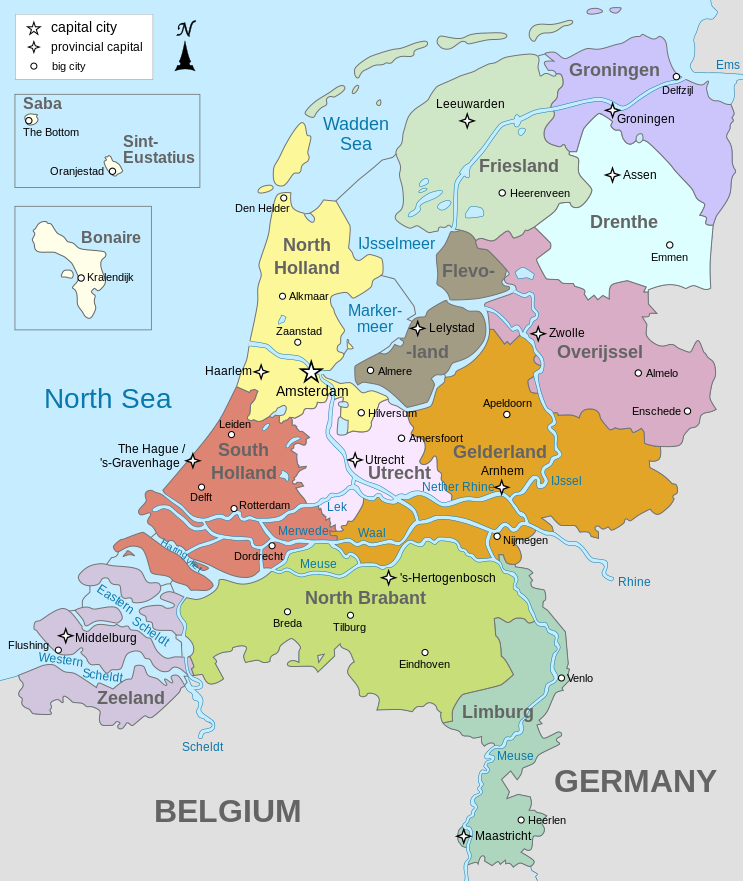
English: Map of The Netherlands (including the special municipalities of Saba, Saint Eustatius and Bonaire; the Caribbean Netherlands), showing provinces, large cities, rivers and lakes. English version
Deutsch: Karte der Niederlande, mit den Provinzen, der Karibischen Niederlande, den Großstädten und den Flüssen und Seen. Englische Version
Bahasa Indonesia: Peta Belanda (termasuk munisipal khusus Saba, Saint Eustatius dan Bonaire; Belanda Karibia), menampilkan provinsi, kota besar, sungai dan danau. Versi bahasa Inggris |
| Dîrok | |
| Çavkanî | Min çêkir |
| Xwedî | Alphathon |
| Guhartoyên din |
[]
|


.svg)
Lîsans
I, the copyright holder of this work, hereby publish it under the following licenses:
Ev pel di bin lîsansa Creative Commons Attribution-Share Alike 3.0 Unported de lîsanskirî ye.
- Tu azad î:
- parve bike – ji bo kopîkirin, belavkirin û weşandina xebatê
- ji bo guhartin û adaptekirina naverokê – ji bo adaptekirina xebatê
- Di bin van mercan de:
- isnad – Divê tu isnadeke maqûl bikî, lînekek pêşkêş bikî ji bo lîsansê, û diyar bikî ku guhartin hatiye kirin an na. Tu dikarî vê yekê bi adilî bi cih bînî, lê ne bi awayê ku wekî lîsansor te an bikaranîna te pejirandibe.
- parvekirinê mîna hev – Ger tu materyalê biguherînî, bizivirînî formeke din, an ava bikî divê beşdariyên xwe di bin eynî lîsansê an lîsansa hevaheng de wekî ya eslî belav bikî.

|
Ev dosye di bin Lîsansa Belgekirina Azad a GNU hate barkirin.
Kopîkirin, belavkirin û guhartin di bin qebûlkirinên lîsansa GNU de ye, versiyona 1.2 versiyoneke kevintirîn a belavkirinê ya ji bo Weqfa Nivîsbara Azad, tê qebûlkirin. Kopyeyek lîsanse di beşa bi sernavê Lîsansa Belgekirina Azad a GNUde cî digre. |
Tu dikarî lîsansa ku tu dixwazî hilbijêrî.
Dîroka daneyê
Ji bo dîtina guhartoya wê demê bişkoka dîrokê bitikîne.
| Dîrok/Katjimêr | Wêneyê biçûk | Mezinahî | Bikarhêner | Şirove | |
|---|---|---|---|---|---|
| niha | 19:28, 19 kanûna paşîn 2024 | | 743 x 881 (1003 KB) | Illchy | File uploaded using svgtranslate tool (https://svgtranslate.toolforge.org/). Added translation for id. |
| 17:43, 29 nîsan 2023 |  | 743 x 881 (987 KB) | Dymitr | File uploaded using svgtranslate tool (https://svgtranslate.toolforge.org/). Added translation for be-tarask. | |
| 09:27, 25 çiriya paşîn 2021 |  | 743 x 881 (909 KB) | Andrei Stroe | File uploaded using svgtranslate tool (https://svgtranslate.toolforge.org/). Added translation for ro. | |
| 08:39, 12 nîsan 2019 |  | 743 x 881 (811 KB) | Thayts | Tweaked text position | |
| 11:32, 17 sibat 2019 |  | 743 x 881 (811 KB) | Thayts | Fixed svg | |
| 11:18, 17 sibat 2019 |  | 743 x 881 (811 KB) | Thayts | Added a bit more spacing between Eastern/Western and Scheldt | |
| 11:06, 17 sibat 2019 |  | 743 x 881 (811 KB) | Thayts | Fixed Eastern Scheldt which wasn't rendered by the MediaWiki engine; removed Belgian city of Antwerp | |
| 05:21, 14 sibat 2019 |  | 743 x 881 (809 KB) | Alphathon | Updated borders | |
| 20:34, 23 tebax 2015 |  | 743 x 881 (847 KB) | Alphathon | Fixed stroke weight on a Friesland lake | |
| 20:27, 23 tebax 2015 |  | 743 x 881 (847 KB) | Alphathon | Covered over the strokes at the mouths of rivers |
Bikaranîna pelê
Ev rûpelên li jêr vê dosyeyê bi kar tînin:
Bikaranîna gerdûnî ya pelê
Ev wîkiyên di rêzê de vê pelê bi kar tînin:
- Bikaranîna di ace.wikipedia.org de
- Bikaranîna di af.wikipedia.org de
- Bikaranîna di ang.wikipedia.org de
- Bikaranîna di an.wikipedia.org de
- Bikaranîna di ar.wikipedia.org de
- Bikaranîna di ay.wikipedia.org de
- Bikaranîna di azb.wikipedia.org de
- Bikaranîna di be-tarask.wikipedia.org de
- Bikaranîna di bg.wikipedia.org de
- Bikaranîna di blk.wikipedia.org de
- Bikaranîna di bn.wikipedia.org de
- Bikaranîna di ceb.wikipedia.org de
- Bikaranîna di diq.wikipedia.org de
- Bikaranîna di en.wikipedia.org de
- Netherlands
- Provinces of the Netherlands
- List of islands of the Netherlands
- King's commissioner
- Geology of the Netherlands
- File talk:Netherlands map large.png
- French war planning 1920–1940
- User talk:Gidonb/Archive 2008
- Template:Provinces of the Netherlands imagemap
- List of windmills in the Netherlands
- Provincial politics in the Netherlands
- 2008–09 KNVB Cup
- User:Alphathon/Gallery
- Portal:Islands
- Wikipedia:Reference desk/Archives/Humanities/2014 September 25
- Bikaranîna di en.wikiversity.org de
- Bikaranîna di eu.wikipedia.org de
- Bikaranîna di fa.wikipedia.org de
- Bikaranîna di fi.wikipedia.org de
- Bikaranîna di fr.wikipedia.org de
- Bikaranîna di gl.wikipedia.org de
- Bikaranîna di haw.wikipedia.org de
- Bikaranîna di he.wikipedia.org de
- Bikaranîna di ia.wikipedia.org de
- Bikaranîna di id.wikipedia.org de
Zêdetir bikaranîna global a vê pelê bibîne.