
Wêne:1950s CIA map of Iraq – tribes of Iraq (Iraqi Kurdistan detail).jpg

Mezinahiya vê pêşdîtinê: 800 × 563 pîksel. Resolusyonên din: 320 × 225 pîksel | 640 × 451 pîksel | 1024 × 721 pîksel | 1280 × 901 pîksel | 2884 × 2031 pîksel.
Dosyeya orjînal (2884 × 2031 pixel, mezinbûnê data: 1,25 MB, MIME-typ: image/jpeg)
| Ev pel ji Wikimedia Commonsê ye. Agahdariya li ser rûpela danasîna pelê li jêr tê nîşandan. |
Danasîn
| Danasîn |
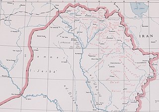
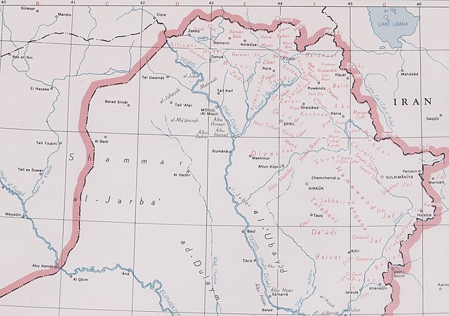
English: Map of Iraq prepared by the United States Central Intelligence Agency's Map Branch circa 1950. Names of Arab tribes are written in black; names of Kurdish tribes are in green. An "Index of Tribes is in the top right, with Arab and Kurdish tribes arranged in columns. Marked at bottom left: "11645", and top right: "RESTRICTED" (struck through). Stamped "FOR OFFICIAL USE ONLY" in red, bottom centre. In the map area itself, the word "RESTRICTED" in red has been deleted at the bottom left, beneath which is printed: "The international boundaries shown on this map do not necessarily correspond in all cases to the boundaries recognized by the U.S. Government." Digitally added to the image, beneath the map: "DECLASSIFIED Authority E.O. 13526" and "NND 76630". |
| Dîrok | |
| Çavkanî |
United States National Archives Published Maps, 1947–2015 Record Group 263: Records of the Central Intelligence Agency, 1894–2002 https://catalog.archives.gov/id/175514185 (National Archives Identifier: 175514185) |
| Xwedî | Map Service Center, Central Intelligence Agency, United States National Security Council |
| Guhartoyên din |

.jpg?uselang=ku-latn)
Lîsans
| This image is a work of a Central Intelligence Agency employee, taken or made as part of that person's official duties. As a Work of the United States Government, this image or media is in the public domain in the United States.
|

|
Dîroka daneyê
Ji bo dîtina guhartoya wê demê bişkoka dîrokê bitikîne.
| Dîrok/Katjimêr | Wêneyê biçûk | Mezinahî | Bikarhêner | Şirove | |
|---|---|---|---|---|---|
| niha | 05:16, 24 gulan 2021 | | 2884 x 2031 (1,25 MB) | GPinkerton | File:1950s CIA map of Iraq – tribes of Iraq.jpg cropped 56 % horizontally, 64 % vertically using CropTool with lossless mode. |
Bikaranîna pelê
Ev rûpelên li jêr vê dosyeyê bi kar tînin:
Bikaranîna gerdûnî ya pelê
Ev wîkiyên di rêzê de vê pelê bi kar tînin:
- Bikaranîna di de.wikipedia.org de
- Bikaranîna di en.wikipedia.org de
- Bikaranîna di simple.wikipedia.org de
.jpg)