
Wêne:Autonome Region Kurdistan (Karte).png

Mezinahiya vê pêşdîtinê: 581 × 599 pîksel. Resolusyonên din: 233 × 240 pîksel | 465 × 480 pîksel | 1012 × 1044 pîksel.
Dosyeya orjînal (1012 × 1044 pixel, mezinbûnê data: 278 KB, MIME-typ: image/png)
| Ev pel ji Wikimedia Commonsê ye. Agahdariya li ser rûpela danasîna pelê li jêr tê nîşandan. |
| Danasîn |
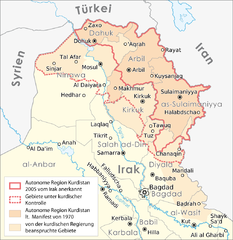
Deutsch: Karte: Autonome Region Kurdistan |
||
| Dîrok | |||
| Çavkanî |
Self made, using |
||
| Xwedî |
Maximilian Dörrbecker (Chumwa)
|
||
| Destûr (Dîsa bikaranînê vê dosyeye) |
I, the copyright holder of this work, hereby publish it under the following license: This file is licensed under the Creative Commons Attribution-Share Alike 2.5 Generic license.
Sie dürfen das Bild zu den folgenden Bedingungen nutzen:
|
||
| Guhartoyên din |
|


.png?uselang=ku-latn)
| Annotations | This image is annotated: View the annotations at Commons |
.png)
Dîroka daneyê
Ji bo dîtina guhartoya wê demê bişkoka dîrokê bitikîne.
| Dîrok/Katjimêr | Wêneyê biçûk | Mezinahî | Bikarhêner | Şirove | |
|---|---|---|---|---|---|
| niha | 13:26, 15 tebax 2016 | | 1012 x 1044 (278 KB) | Denniss | Reverted to version as of 17:02, 22 September 2008 (UTC) |
| 19:32, 5 tebax 2016 |  | 1012 x 1044 (227 KB) | Beshogur | Reverted to version as of 06:40, 21 June 2008 (UTC) Mosul, Tal Afar is not under KRG controll. | |
| 18:55, 16 îlon 2011 |  | 1012 x 1044 (278 KB) | Kathovo | Reverted to version as of 21:38, 14 August 2010 | |
| 20:51, 19 tebax 2010 |  | 1012 x 1044 (202 KB) | Saadwand | Reverted to version as of 11:32, 14 August 2010 | |
| 21:38, 14 tebax 2010 |  | 1012 x 1044 (278 KB) | 84user | Reverted to version as of 17:02, 22 September 2008 reverting apparenty erroneous colour change | |
| 11:32, 14 tebax 2010 |  | 1012 x 1044 (202 KB) | Abuadab | minore colour change. | |
| 17:02, 22 îlon 2008 |  | 1012 x 1044 (278 KB) | Chumwa | Informationen aus [http://www.washingtonpost.com/wp-dyn/content/graphic/2008/09/13/GR2008091300327.html dieser Karte] integriert. | |
| 06:40, 21 hezîran 2008 |  | 1012 x 1044 (227 KB) | Chumwa | diverse Anmerkungen eingearbeitet | |
| 05:00, 20 hezîran 2008 |  | 1012 x 1044 (284 KB) | Chumwa | Komplett neuer Aufbau der Karte | |
| 17:24, 16 hezîran 2008 |  | 831 x 784 (37 KB) | Chumwa | {{Information |Description= {{ de }} Karte: Autonome Region Kurdistan |Source=Self made, using * base map #1 * base map #2 |Date=June 2008 |Author=[[:de:User:Chumwa|Maximil |
Bikaranîna pelê
Ev 2 rûpel li jêr vê dosyeyê bi kar tînin:
Bikaranîna gerdûnî ya pelê
Ev wîkiyên di rêzê de vê pelê bi kar tînin:
- Bikaranîna di de.wikipedia.org de
- Bikaranîna di tr.wikipedia.org de
.png)