
Wêne:Geographic map of Somaliland.svg

Size of this PNG preview of this SVG file: 800 × 506 pîksel. Resolusyonên din: 320 × 202 pîksel | 640 × 405 pîksel | 1024 × 648 pîksel | 1280 × 810 pîksel | 2560 × 1619 pîksel | 4110 × 2600 pîksel.
Dosyeya orjînal (Daneya SVG, mezinbûna rast: 4110 × 2600 pixel; mezinbûna daneyê: 11,09 MB)
| Ev pel ji Wikimedia Commonsê ye. Agahdariya li ser rûpela danasîna pelê li jêr tê nîşandan. |
Danasîn
| Danasîn |
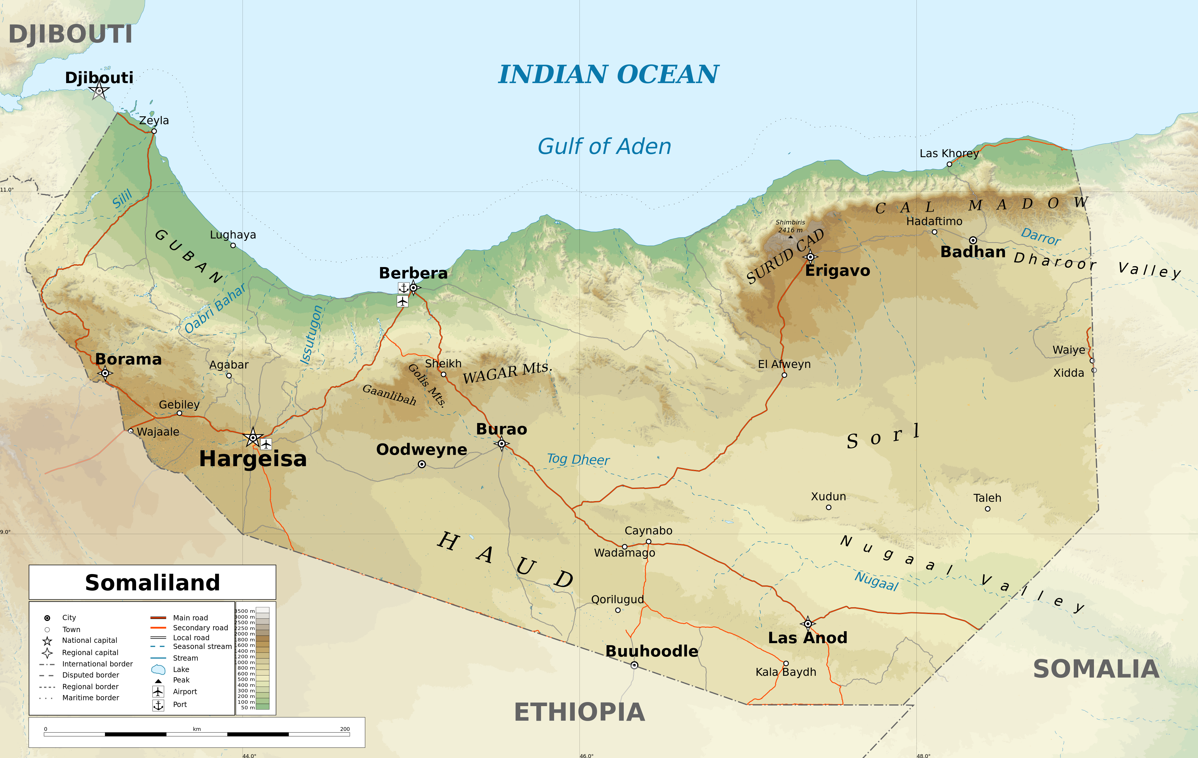
English: Geographic map of Somaliland. Geographic limits of the map:
|
| Dîrok | |
| Çavkanî |
Min çêkir
|
| Xwedî | Ikonact |
| Destûr (Dîsa bikaranînê vê dosyeye) |
Any use of this map is subject of the license(s) stated below with the condition that you credit (Wikimedia Commons user: Ikonact) as the author . A message with a reply address would also be greatly appreciated. |
| Guhartoyên din |
[]
|
| SVG genesis |


Assessment
|
Lîsans
I, the copyright holder of this work, hereby publish it under the following license:
This file is licensed under the Creative Commons Attribution-Share Alike 4.0 International license.
- Tu azad î:
- parve bike – ji bo kopîkirin, belavkirin û weşandina xebatê
- ji bo guhartin û adaptekirina naverokê – ji bo adaptekirina xebatê
- Di bin van mercan de:
- isnad – Divê tu isnadeke maqûl bikî, lînekek pêşkêş bikî ji bo lîsansê, û diyar bikî ku guhartin hatiye kirin an na. Tu dikarî vê yekê bi adilî bi cih bînî, lê ne bi awayê ku wekî lîsansor te an bikaranîna te pejirandibe.
- parvekirinê mîna hev – Ger tu materyalê biguherînî, bizivirînî formeke din, an ava bikî divê beşdariyên xwe di bin eynî lîsansê an lîsansa hevaheng de wekî ya eslî belav bikî.
Dîroka daneyê
Ji bo dîtina guhartoya wê demê bişkoka dîrokê bitikîne.
| Dîrok/Katjimêr | Wêneyê biçûk | Mezinahî | Bikarhêner | Şirove | |
|---|---|---|---|---|---|
| niha | 17:20, 13 sibat 2022 | | 4110 x 2600 (11,09 MB) | Jacob300 | Reverted to version as of 22:29, 26 August 2021 (UTC) |
| 08:01, 27 tebax 2021 |  | 4110 x 2600 (11,27 MB) | Ikonact | Reverted to version as of 11:59, 26 August 2021 (UTC) - the eastern border is disputed and should stay as such | |
| 22:29, 26 tebax 2021 |  | 4110 x 2600 (11,09 MB) | Siirski | Corrected eastern border | |
| 11:59, 26 tebax 2021 |  | 4110 x 2600 (11,27 MB) | Ikonact | final touch | |
| 09:37, 26 tebax 2021 |  | 4110 x 2600 (11,36 MB) | Ikonact | legend, names in En | |
| 20:47, 25 tebax 2021 |  | 4110 x 2600 (11,33 MB) | Ikonact | + mnts nammes | |
| 20:07, 25 tebax 2021 |  | 4110 x 2600 (11,32 MB) | Ikonact | font | |
| 20:03, 25 tebax 2021 |  | 4110 x 2600 (11,32 MB) | Ikonact | more data | |
| 12:56, 24 tebax 2021 |  | 4110 x 2600 (16,17 MB) | Ikonact | == {{int:filedesc}} == {{Information |description={{en|Geographic map of {{W|Somaliland}}. Geographic limits of the map:}} *N: 12.12° N *S: 7.69° N *W: 42.56° E *E: 49.67° E Equidistant Cylindrical projection; WGS 84 datum |date=2021-08-24 |source={{own}} *Sources of data:<br/> **Topography: SRTM3 v4 (public domain);<br/> **Rivers and water bodies: Natural Earth, © OpenStreetMap contributors **Borders and towns: © OpenStreetMap contributors;<br/> *Tool:<br/> **The map is created with Octave s... |
Bikaranîna pelê
Ev rûpelên li jêr vê dosyeyê bi kar tînin:
Bikaranîna gerdûnî ya pelê
Ev wîkiyên di rêzê de vê pelê bi kar tînin:
- Bikaranîna di ar.wikipedia.org de
- Bikaranîna di bg.wikipedia.org de
- Bikaranîna di ca.wikipedia.org de
- Bikaranîna di da.wikipedia.org de
- Bikaranîna di de.wikipedia.org de
- Bikaranîna di en.wikipedia.org de
- Bikaranîna di fr.wikipedia.org de
- Bikaranîna di ga.wikipedia.org de
- Bikaranîna di gl.wikipedia.org de
- Bikaranîna di hu.wikipedia.org de
- Bikaranîna di id.wikipedia.org de
- Bikaranîna di is.wikipedia.org de
- Bikaranîna di ja.wikipedia.org de
- Bikaranîna di lt.wikipedia.org de
- Bikaranîna di ru.wikivoyage.org de
- Bikaranîna di sh.wikipedia.org de
- Bikaranîna di so.wikipedia.org de
- Bikaranîna di sv.wikipedia.org de
- Bikaranîna di www.wikidata.org de
- Bikaranîna di zh.wikipedia.org de