
Wêne:Hewler governorate 2012.png

Mezinahiya vê pêşdîtinê: 469 × 599 pîksel. Resolusyonên din: 188 × 240 pîksel | 376 × 480 pîksel | 700 × 894 pîksel.
Dosyeya orjînal (700 × 894 pixel, mezinbûnê data: 62 KB, MIME-typ: image/png)
| Ev pel ji Wikimedia Commonsê ye. Agahdariya li ser rûpela danasîna pelê li jêr tê nîşandan. |
Danasîn
| Danasîn |
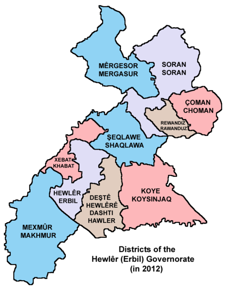
English: Map showing the districts of the Hewlêr (Erbil) Governorate of Kurdistan Region in Iraq (in 2012). |
| Dîrok | |
| Çavkanî | Min çêkir |
| Xwedî | PANONIAN |
Lîsans
I, the copyright holder of this work, hereby publish it under the following license:
| This file is made available under the Creative Commons CC0 1.0 Universal Public Domain Dedication. | |
| The person who associated a work with this deed has dedicated the work to the public domain by waiving all of their rights to the work worldwide under copyright law, including all related and neighboring rights, to the extent allowed by law. You can copy, modify, distribute and perform the work, even for commercial purposes, all without asking permission.
|
Refences
Borders of districts of the Hewlêr (Erbil) Governorate are made in accordance with these maps provided by the Kurdistan Region Statistics Office:
- http://www.krso.net/en/maps
- http://www.krso.net/documents/78/SubDistricts%20of%20the%20Governorates%20of%20Kurdistan%20Region.jpg
- http://www.krso.net/documents/38/Districts%20of%20the%20Governorates%20of%20Kurdistan%20Region.jpg
Dîroka daneyê
Ji bo dîtina guhartoya wê demê bişkoka dîrokê bitikîne.
| Dîrok/Katjimêr | Wêneyê biçûk | Mezinahî | Bikarhêner | Şirove | |
|---|---|---|---|---|---|
| niha | 19:57, 10 îlon 2014 | | 700 x 894 (62 KB) | PANONIAN | {{Information |Description ={{en|1=Map showing the districts of the Hewlêr (Erbil) Governorate of Kurdistan Region in Iraq (in 2012).}} |Source ={{own}} |Author =PANONIAN |Date =2014 |Permission = |ot... |
Bikaranîna pelê
Ev 12 rûpel li jêr vê dosyeyê bi kar tînin:
Bikaranîna gerdûnî ya pelê
Ev wîkiyên di rêzê de vê pelê bi kar tînin:
- Bikaranîna di arc.wikipedia.org de
- Bikaranîna di ar.wikipedia.org de
- شقلاوة
- قضاء مخمور
- أربيل
- ناحية سيدكان
- جومان
- قضاء أربيل
- ناحية بحركة
- ناحية شمامك
- ناحية صلاح الدين
- ناحية هيران
- ناحية حرير
- ناحية باسرمة
- ناحية باليسان
- قضاء ميركسور
- ناحية دارتو
- ناحية قوشتبة
- ناحية رزكاري
- ناحية كسنزان
- ناحية خليفان
- ناحية ديانا
- ناحية بارزان
- ناحية بيران
- ناحية شيروان مزن
- ناحية مزني
- ناحية كورتو
- ناحية دارشكران
- ناحية كوركوسك
- ناحية ورتي
- قضاء جومان
- ناحية سميلان
- ناحية كلالة
- ناحية قسري
- ناحية طق طق
- ناحية شورش
- ناحية آشتي
- ناحية سكتان
- ناحية سيكردكان
- خبات
- ناحية قراج
- قالب:محافظة أربيل
- ناحية كنديناوة
- Bikaranîna di arz.wikipedia.org de
- Bikaranîna di bg.wikipedia.org de
- Bikaranîna di bn.wikipedia.org de
- Bikaranîna di ceb.wikipedia.org de
- Bikaranîna di ckb.wikipedia.org de
Zêdetir bikaranîna global a vê pelê bibîne.