
Wêne:March 2010 Turkey earthquake intensity USGS.jpg
Mezinahiya vê pêşdîtinê: 514 × 600 pîksel. Resolusyonên din: 206 × 240 pîksel | 612 × 714 pîksel.
Dosyeya orjînal (612 × 714 pixel, mezinbûnê data: 129 KB, MIME-typ: image/jpeg)
| Ev pel ji Wikimedia Commonsê ye. Agahdariya li ser rûpela danasîna pelê li jêr tê nîşandan. |
Danasîn
| Danasîn |
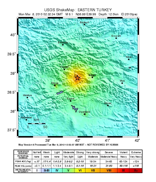
English: Shake map of the magnitude 6.1 earthquake occurring at Elâzığ, Turkey on March 8, 2010. Epicenter marked at star. Realized by USGS on March 8, 2010. |
|||
| Dîrok | ||||
| Çavkanî | USGS | |||
| Xwedî | United States Geological Survey | |||
| Destûr (Dîsa bikaranînê vê dosyeye) |
|
Dîroka daneyê
Ji bo dîtina guhartoya wê demê bişkoka dîrokê bitikîne.
| Dîrok/Katjimêr | Wêneyê biçûk | Mezinahî | Bikarhêner | Şirove | |
|---|---|---|---|---|---|
| niha | 10:23, 20 adar 2010 | | 612 x 714 (129 KB) | A7x | {{Information |Description={{en|1=Shake map of the magnitude 6.1 earthquake occurring at Elâzığ, Turkey on March 8, 2010. Epicenter marked at star. Realized by USGS on March 8, 2010.}} |Source=[http://earthquake.usgs.gov/earthquakes/shakemap/global/sha |
Bikaranîna pelê
Ev rûpelên li jêr vê dosyeyê bi kar tînin:
Bikaranîna gerdûnî ya pelê
Ev wîkiyên di rêzê de vê pelê bi kar tînin:
- Bikaranîna di ca.wikipedia.org de
- Bikaranîna di de.wikipedia.org de
- Bikaranîna di en.wikipedia.org de
- Bikaranîna di fr.wikipedia.org de
- Bikaranîna di id.wikipedia.org de
- Bikaranîna di ms.wikipedia.org de
- Bikaranîna di nl.wikipedia.org de
- Bikaranîna di pl.wikipedia.org de
- Bikaranîna di pt.wikipedia.org de
- Bikaranîna di ru.wikipedia.org de
- Bikaranîna di tr.wikipedia.org de
- Bikaranîna di uk.wikipedia.org de
- Bikaranîna di www.wikidata.org de