
Wêne:Saxton Brecknock Cardigan Carmarthen Radnor.jpg

Mezinahiya vê pêşdîtinê: 762 × 599 pîksel. Resolusyonên din: 305 × 240 pîksel | 610 × 480 pîksel | 769 × 605 pîksel.
Dosyeya orjînal (769 × 605 pixel, mezinbûnê data: 174 KB, MIME-typ: image/jpeg)
| Ev pel ji Wikimedia Commonsê ye. Agahdariya li ser rûpela danasîna pelê li jêr tê nîşandan. |
Danasîn
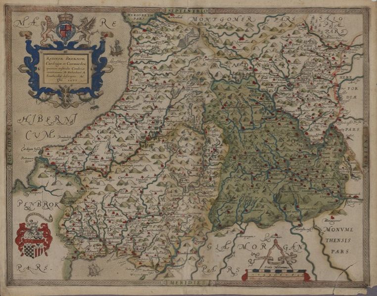
| Brecknock, Cardigan, Carmarthen and Radnor
( |
||||||||||||||||||||||||
|---|---|---|---|---|---|---|---|---|---|---|---|---|---|---|---|---|---|---|---|---|---|---|---|---|
| Artist |
Saxton, Christopher b.1542? |
|||||||||||||||||||||||
| Sernav |
Brecknock, Cardigan, Carmarthen and Radnor |
|||||||||||||||||||||||
| Danasîn |
Saxton's Welsh County maps were first published in William Camden's 'Britannia', 1607. This was the final Latin version, and the first to be illustrated with maps. |
|||||||||||||||||||||||
| Dîrok | 1607 | |||||||||||||||||||||||
| Dimensions | Bilindahî: 190 mm; panî: 260 mm | |||||||||||||||||||||||
| Berhevok |
|
|||||||||||||||||||||||
| Not | Scale [ca.1:196,000]. 3.3 inches = 10 miles. | |||||||||||||||||||||||
| Source/Photographer |
|
|||||||||||||||||||||||
| Destûr (Dîsa bikaranînê vê dosyeye) |
|
|||||||||||||||||||||||


Dîroka daneyê
Ji bo dîtina guhartoya wê demê bişkoka dîrokê bitikîne.
| Dîrok/Katjimêr | Wêneyê biçûk | Mezinahî | Bikarhêner | Şirove | |
|---|---|---|---|---|---|
| niha | 13:01, 21 çiriya pêşîn 2015 | | 769 x 605 (174 KB) | Jason.nlw | User created page with UploadWizard |
Bikaranîna pelê
Ev rûpelên li jêr vê dosyeyê bi kar tînin:
Bikaranîna gerdûnî ya pelê
Ev wîkiyên di rêzê de vê pelê bi kar tînin:
- Bikaranîna di cy.wikipedia.org de
- Bikaranîna di es.wikipedia.org de
- Bikaranîna di ru.wikipedia.org de
- Bikaranîna di www.wikidata.org de