
Wêne:IBCAO betamap.jpg
Mezinahiya vê pêşdîtinê: 526 × 599 pîksel. Resolusyonên din: 211 × 240 pîksel | 421 × 480 pîksel | 762 × 868 pîksel.
Dosyeya orjînal (762 × 868 pixel, mezinbûnê data: 710 KB, MIME-typ: image/jpeg)
| Ev pel ji Wikimedia Commonsê ye. Agahdariya li ser rûpela danasîna pelê li jêr tê nîşandan. |
| Description |
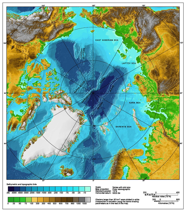
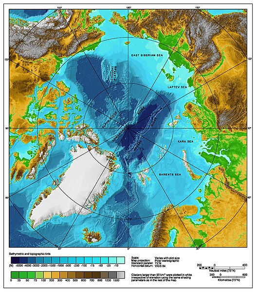
Bathymetric map of the Arctic Ocean |
|||||||||
| Çavkanî | http://www.ngdc.noaa.gov/mgg/image/IBCAO_betamap.jpg | |||||||||
| Destûr (Dîsa bikaranînê vê dosyeye) |
|
|||||||||
| Geotemporal data | ||||||||||
| Bounding box |
|
|||||||||
| Georeferencing | ||||||||||
| Guhartoyên din |
Derivative works of this file: |
|||||||||
Dîroka daneyê
Ji bo dîtina guhartoya wê demê bişkoka dîrokê bitikîne.
| Dîrok/Katjimêr | Wêneyê biçûk | Mezinahî | Bikarhêner | Şirove | |
|---|---|---|---|---|---|
| niha | 00:29, 2 tebax 2007 | | 762 x 868 (710 KB) | Mikkalai | Source: http://www.ngdc.noaa.gov/mgg/image/IBCAO_betamap.jpg Bathymetric map of the w:Arctic Ocean |
Bikaranîna pelê
Ev rûpelên li jêr vê dosyeyê bi kar tînin:
Bikaranîna gerdûnî ya pelê
Ev wîkiyên di rêzê de vê pelê bi kar tînin:
- Bikaranîna di af.wikipedia.org de
- Bikaranîna di ar.wikipedia.org de
- Bikaranîna di ary.wikipedia.org de
- Bikaranîna di ast.wikipedia.org de
- Bikaranîna di avk.wikipedia.org de
- Bikaranîna di azb.wikipedia.org de
- Bikaranîna di bcl.wikipedia.org de
- Bikaranîna di be.wikipedia.org de
- Bikaranîna di bg.wikipedia.org de
- Bikaranîna di bh.wikipedia.org de
- Bikaranîna di bn.wikipedia.org de
- Bikaranîna di bxr.wikipedia.org de
- Bikaranîna di ca.wikipedia.org de
- Bikaranîna di ceb.wikipedia.org de
- Bikaranîna di chr.wikipedia.org de
- Bikaranîna di co.wikipedia.org de
- Bikaranîna di crh.wikipedia.org de
- Bikaranîna di cs.wikipedia.org de
- Bikaranîna di da.wikipedia.org de
- Bikaranîna di de.wikipedia.org de
- Bikaranîna di dty.wikipedia.org de
- Bikaranîna di en.wikipedia.org de
- Talk:Lomonosov Ridge
- Territorial claims in the Arctic
- Arktika 2007
- Portal:Maps/Maps/Geographic
- Portal:Maps/Maps/Geographic/2
- Arctic Ocean
- User:Wiki User 68/My Portal/Selected geography/1
- List of Russian explorers
- Wikipedia:Reference desk/Archives/Science/2015 May 29
- User:Joelton Ivson/Gather lists/24441 – Conflitos internacionais
- Portal:Oceans
- Bikaranîna di en.wikinews.org de
- Bikaranîna di en.wikiversity.org de
- Bikaranîna di eo.wikipedia.org de
- Bikaranîna di es.wikipedia.org de
Zêdetir bikaranîna global a vê pelê bibîne.