
Wêne:Uspaintedrelief.png

Mezinahiya vê pêşdîtinê: 800 × 578 pîksel. Resolusyonên din: 320 × 231 pîksel | 640 × 463 pîksel | 1024 × 740 pîksel | 1280 × 925 pîksel | 2336 × 1689 pîksel.
Dosyeya orjînal (2336 × 1689 pixel, mezinbûnê data: 3,46 MB, MIME-typ: image/png)
| Ev pel ji Wikimedia Commonsê ye. Agahdariya li ser rûpela danasîna pelê li jêr tê nîşandan. |
Danasîn
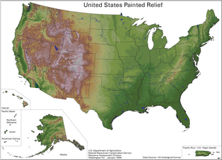
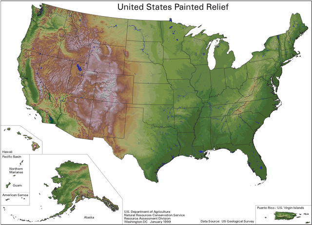
English: A painted relief map of the United States, showing shaded topographic information.
- Using U.S. Geological Survey data and published by the Natural Resources Conservation Service.
- The color scheme for the shading was done by Karl Musser.
Lîsans
This work is in the public domain in the United States because it is a work prepared by an officer or employee of the United States Government as part of that person’s official duties under the terms of Title 17, Chapter 1, Section 105 of the US Code.
Note: This only applies to original works of the Federal Government and not to the work of any individual U.S. state, territory, commonwealth, county, municipality, or any other subdivision. This template also does not apply to postage stamp designs published by the United States Postal Service since 1978. (See § 313.6(C)(1) of Compendium of U.S. Copyright Office Practices). It also does not apply to certain US coins; see The US Mint Terms of Use.
|
 | |
| This file has been identified as being free of known restrictions under copyright law, including all related and neighboring rights. | ||
Dîroka daneyê
Ji bo dîtina guhartoya wê demê bişkoka dîrokê bitikîne.
| Dîrok/Katjimêr | Wêneyê biçûk | Mezinahî | Bikarhêner | Şirove | |
|---|---|---|---|---|---|
| niha | 15:37, 3 kanûna paşîn 2007 | | 2336 x 1689 (3,46 MB) | Kmusser | This is a painted relief map of the United States using U.S. Geological Survey data and published by the Natural Resources Conservation Service. The color scheme for the shading was done by Karl Musser. |
Bikaranîna pelê
Ev rûpelên li jêr vê dosyeyê bi kar tînin:
Bikaranîna gerdûnî ya pelê
Ev wîkiyên di rêzê de vê pelê bi kar tînin:
- Bikaranîna di arz.wikipedia.org de
- Bikaranîna di bg.wikipedia.org de
- Bikaranîna di en.wikipedia.org de
- Bikaranîna di incubator.wikimedia.org de
- Bikaranîna di io.wikipedia.org de
- Bikaranîna di no.wikipedia.org de
- Bikaranîna di or.wikipedia.org de
- Bikaranîna di pt.wikipedia.org de
- Bikaranîna di tr.wikipedia.org de
- Bikaranîna di tum.wikipedia.org de
- Bikaranîna di zh.wikipedia.org de