
Wêne:East Francia 843.svg

Size of this PNG preview of this SVG file: 500 × 380 pîksel. Resolusyonên din: 316 × 240 pîksel | 632 × 480 pîksel | 1011 × 768 pîksel | 1280 × 973 pîksel | 2560 × 1946 pîksel.
Dosyeya orjînal (Daneya SVG, mezinbûna rast: 500 × 380 pixel; mezinbûna daneyê: 933 KB)
| Ev pel ji Wikimedia Commonsê ye. Agahdariya li ser rûpela danasîna pelê li jêr tê nîşandan. |
Danasîn
This W3C-unspecified vector image was created with Inkscape .


.svg)
.svg)
.svg)
.svg)
.svg)


.svg)
.svg)
.svg)


.png)
.png)


.svg)


.svg)

.svg)


.svg)
.svg)
.svg)
.svg)


.svg)
.png)


.svg)


.svg)
.svg)


.svg)


.svg)


.svg)
.svg)
.svg)
.svg)
.svg)
.svg)
.svg)
_cropped.svg)
.svg)
.svg)
.svg)
.svg)
.svg)
.svg)
.svg)
.svg)
.svg)
.svg)
.svg)
.svg)
.svg)
.svg)
.svg)
.svg)
.svg)
.svg)
.svg)
.svg)
.svg)
.svg)
.svg)
.svg)
.svg)
.svg)
.svg)
.svg)
.svg)
.svg)
.svg)
.svg)
.svg)
.svg)
.svg)
.svg)
.svg)
.svg)
.svg)
.svg)
.svg)
.svg)
.svg)
.svg)
.svg)
Lîsans
This file is licensed under the Creative Commons Attribution-Share Alike 4.0 International license.
- Tu azad î:
- parve bike – ji bo kopîkirin, belavkirin û weşandina xebatê
- ji bo guhartin û adaptekirina naverokê – ji bo adaptekirina xebatê
- Di bin van mercan de:
- isnad – Divê tu isnadeke maqûl bikî, lînekek pêşkêş bikî ji bo lîsansê, û diyar bikî ku guhartin hatiye kirin an na. Tu dikarî vê yekê bi adilî bi cih bînî, lê ne bi awayê ku wekî lîsansor te an bikaranîna te pejirandibe.
- parvekirinê mîna hev – Ger tu materyalê biguherînî, bizivirînî formeke din, an ava bikî divê beşdariyên xwe di bin eynî lîsansê an lîsansa hevaheng de wekî ya eslî belav bikî.
Dîroka daneyê
Ji bo dîtina guhartoya wê demê bişkoka dîrokê bitikîne.
| Dîrok/Katjimêr | Wêneyê biçûk | Mezinahî | Bikarhêner | Şirove | |
|---|---|---|---|---|---|
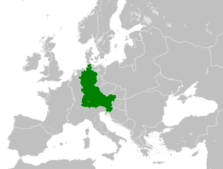
| niha | 10:06, 6 tebax 2021 | | 500 x 380 (933 KB) | E-960 | Vassal states (aka Slavic tribes) did not make up the territory of East Francia, also in most cases it only represented an alliance with East Francia rather than subjugation. |
| 02:25, 26 gulan 2016 |  | 500 x 380 (932 KB) | Alphathon | == {{int:filedesc}} == {{Inkscape}} {{Information |Description={{en|A map of East Francia within Europe circa 843 CE, following the treaty of Verdun.}} |Source= {{Derived from|Blank_map_of_Europe.svg|display=50}} '''Data sour... |
Bikaranîna pelê
Ev rûpelên li jêr vê dosyeyê bi kar tînin:
Bikaranîna gerdûnî ya pelê
Ev wîkiyên di rêzê de vê pelê bi kar tînin:
- Bikaranîna di azb.wikipedia.org de
- Bikaranîna di bg.wikipedia.org de
- Bikaranîna di ceb.wikipedia.org de
- Bikaranîna di cs.wikipedia.org de
- Bikaranîna di da.wikipedia.org de
- Bikaranîna di el.wikipedia.org de
- Bikaranîna di en.wikipedia.org de
- Bikaranîna di es.wikipedia.org de
- Bikaranîna di et.wikipedia.org de
- Bikaranîna di fa.wikipedia.org de
- Bikaranîna di fi.wikipedia.org de
- Bikaranîna di fr.wikipedia.org de
- Bikaranîna di fy.wikipedia.org de
- Bikaranîna di he.wikipedia.org de
- Bikaranîna di hr.wikipedia.org de
- Bikaranîna di hy.wikipedia.org de
- Bikaranîna di id.wikipedia.org de
- Bikaranîna di it.wikipedia.org de
- Bikaranîna di ja.wikipedia.org de
- Bikaranîna di ko.wikipedia.org de
- Bikaranîna di la.wikipedia.org de
- Bikaranîna di lv.wikipedia.org de
- Bikaranîna di mk.wikipedia.org de
- Bikaranîna di pl.wikipedia.org de
- Bikaranîna di pt.wikipedia.org de
- Bikaranîna di ru.wikipedia.org de
- Bikaranîna di sl.wikipedia.org de
- Bikaranîna di sr.wikipedia.org de
- Bikaranîna di th.wikipedia.org de
- Bikaranîna di tr.wikipedia.org de
- Bikaranîna di uk.wikipedia.org de
- Bikaranîna di vi.wikipedia.org de
- Bikaranîna di zh.wikipedia.org de
Zêdetir bikaranîna global a vê pelê bibîne.