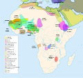
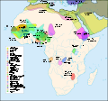
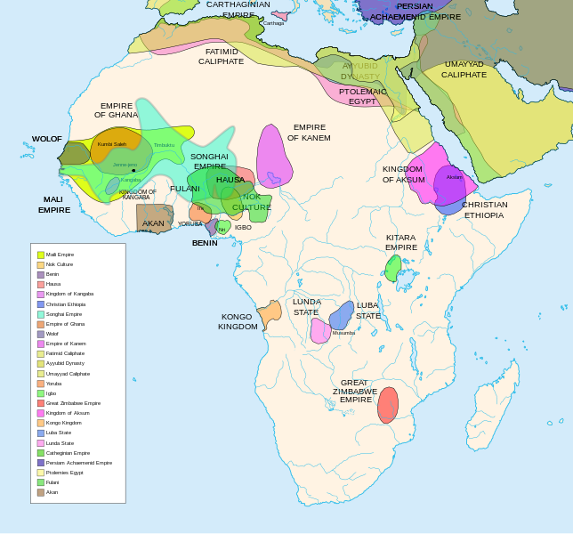
Wêne:African-civilizations-map-pre-colonial.svg
Naverokên rûpelê bi zimanên din nayê destekkirin.
Ji Wîkîpediya, ensîklopediya azad.

Dosyeya orjînal(Daneya SVG, mezinbûna rast: 1390 × 1295 pixel; mezinbûna daneyê: 488 KB)


W3C-validity not checked.

Danasîn

Danasîn

Africa History Atlas

Diachronic map showing pre-colonial cultures of Africa (spanning roughly 500 BCE to 1500 CE)

This map is "an artistic interpretation" using multiple and disparate sources.
Dîrok
Çavkanî Min çêkir
Xwedî Jeff Israel (ZyMOS)
Guhartoyên din

Derivative works of this file:  African-civilizations-map-imperial.png

Civilizations

These civilizations are shown on the map above

Mali Empire (done):
        [4], [5], [6], [7], [8](1300), 14

Nok Culture(done):
        http://perso.orange.fr/miltiade/Civilisation_de_Nok.htm
        [5]

Fulani empire (aka sokoto empire, Sokoto Calphate, Fulani Empire of Sokoto)  (fulani people are different) (done):
        [2], [10e], [11e]
Akan States (generric term for states with the akan people)(Done): 
 [7], 
Benin: (done)
        [7],[14],[16]
Hausa (done)
        [7], [10],[16]

Kingdon of Kangaba (1000AD?) (done)
        [8](1235)

Christian Ethiopia(done)
        [5]

Songhai Empire (done)
        http://commons.wikimedia.org/wiki/Image:Mapa_shonghai.svg
        [3], [4], [5], [6], [7], [8](1300), [16]
        http://www.zum.de/whkmla/histatlas/westafrica/haxmali.html
        http://empathosnationenterprises.com/Consulate/EN-Library/Black-Studies/afempire.html

Empire of Ghana (done):
        [4], [5], [6], [7]

Wolof: (15th century) (done)
        [2],[2c],[14]

Empire of Kanem:(done)
        [15]

Fatimid caliphate(done) 909-1171AD
        [2b],[6b]

Ayyubid dynasty (done) 1171-1250ad
        [1b], [5e], [6e]

Umayyad Caliphate (done) 661-750
        [5b]

Yoruba yorubaland    (done)
        [4b],[2c]

Igbo    (done)
        [4b],

Great Zimbabwe (done):
        [5], [7]

Kingdom of aksum (Axum?) 1bc-7ad  (done)
        [12b],[14b],[15b]

Kongo Kingdom     (done)
        [1c], [2c],[15]

Luba State (done) 15-19th century
        [2c],[4c]

Lunda State (done) 15-19th century
        [2c],[4c],[16]

Carthaginian Empire(done) (220BCE) Carthage
        [2c], [3c]

Persian Achaemenid Empire (done)
        [2e],3e].4e],[

THE PTOLEMIES (done)
        [8e], [9e]

Civilizations to be added

These civilizations have not been added because the borders have not yet been confirmed, or there is some uncertainty if they are a true civilization. Please add them to the map if you are able to define the borders of these civilizations.


Mane (1000-2000)(city) [41]

Kano (independent city-state) (1000-1903):
 [14]

Kaarta (kingdom of Kaarta) (1753-1854):
 [14]

Macina (Macina Empire) (aka Dina of Massina, Sise Jihad state, and Caliphate of Hamdullahi) (1818-1862):
 [14]

Segou (city 1620):
 [14]

Kingdom of Fouta Djallon (Futa Djalon or Kingdom of Fuuta Jallon):
 [14]

Hausa Bakwai (initial stage Hausa):
 [11e]

Wassoulou Empire (Ouassoulou) (1878 - 1898) :
 [14]

Kénédougou Kingdom (Kenedougou) (1650-1898):
 [14]

Ouagadougou (15th century CITY):
 [14]

Ashanti Kingdom:
	[14]

Dahomey:
	[14]

Gando (16th century town):
	[14]

kingdom of Takrur (c. 800 - c. 1285) :
	[8](1300), [13]

Oyo empire (1400-1796)


Bornu Empire (1396-1893):
        [2],[15], [10e]

Bornu-Kanem (a portion of kanem history where they merged):
	[7],[2c]

Wodaabe (a people of africa):
	[10]

Mamluk Sultanate of Egypt (1174-1820):
	[2],[12], 

Kush?Kushite kingdom?:

Axum (see kingdom of aksum):

Buganda kingdom (changed to Unganda, but remained as Buganda people):

Lozi???:

Malawi Empire (late 15th centure and converted to Malawi Contry):

Kilwa (Kilwa Kisiwani, 9th century,  is an Islamic community is present day tanzania):
	[2c]

Abyssinia???:
        [2], [7]

Soha????:
        [2],

Nubia (Makuria, Nobatia, Alodia kingdom):
	[7], 

Kingdom of Kerma(2500BC-1520BC):

=North Central=

Sahariano??:
	[1], 

Maban????????:
        [1],

Fur(a people:
        [1],

Sudanes Central (language Central Sudanic):
        [1],

=East Central=

Sudanes Meridional???:
        [1],

Berta(language>:
        [1],

Kunama(a people):
        [1],

Komuz???instument:
        [1],

Aksumite Civilization
	[7b], [9b(maybey], [13b(aksum)]

Kingdom of Sheva???
	[8b]

Egypt
	[10b]

JolofEmpire (also called Dyolof or Wolof), wolof should be changed to this:
	[11b]


Meroe(city, capital of Kushitic Kingdom)) 
	[12b]

Bantu(ethnic group)
	[12b]

Khoisan(ethnic group)
	[12b]

Almoravid Empire
	[5c], [1f]
	
Monomotapa
	[2c],[16]

Lozi
	[2c]

Zulu Kingdom
	[2c]

Merina
	[2c]

Malawi
	[2c]

Rawanda
	[2c]

Buganada
	[2c]

Kazembe
	[4c]


Punt (3000BC-1000BC):
	location lost in time

D'mt (800BC-100BC):


Gudit (1000AD):

Zagwe Dynasty (1000-1268AD):
	[6e]
	
Solomonic dynasty (1270-1974AD)

Himyar:
	[1d]

Qataban:
	[1d]

Saba:
	[1d]

Hadhramaut:
	[1d]

Thutmoses 1
	[1e]

Ramesses II
	[1e]

Assurbanipal, empire of 
	[7e]

Mbunda Kingdom
	[12e], [13e]

Editing this page and map

Suggestions before editing this map: Be sure to confirm it with multiple sources, and that it would be considered a true civilization. Also if you add to the map please name the layers and objects to keep it organized. A lot of the civilizations on this page do not have the times they existed. If this could be added it would be very beneficial. Then the map could be easily split into eras.

References

The original map came from


Lîsans

I, the copyright holder of this work, hereby publish it under the following licenses:
GNU head Ev dosye di bin Lîsansa Belgekirina Azad a GNU hate barkirin.

Kopîkirin, belavkirin û guhartin di bin qebûlkirinên lîsansa GNU de ye, versiyona 1.2 versiyoneke kevintirîn a belavkirinê ya ji bo Weqfa Nivîsbara Azad, tê qebûlkirin. Kopyeyek lîsanse di beşa bi sernavê Lîsansa Belgekirina Azad a GNUde cî digre.

w:en:Creative Commons
isnad parvekirinê mîna hev
This file is licensed under the Creative Commons Attribution-Share Alike 3.0 Unported, 2.5 Generic, 2.0 Generic and 1.0 Generic license.
Tu azad î:
  • parve bike – ji bo kopîkirin, belavkirin û weşandina xebatê
  • ji bo guhartin û adaptekirina naverokê – ji bo adaptekirina xebatê
Di bin van mercan de:
  • isnad – Divê tu isnadeke maqûl bikî, lînekek pêşkêş bikî ji bo lîsansê, û diyar bikî ku guhartin hatiye kirin an na. Tu dikarî vê yekê bi adilî bi cih bînî, lê ne bi awayê ku wekî lîsansor te an bikaranîna te pejirandibe.
  • parvekirinê mîna hev – Ger tu materyalê biguherînî, bizivirînî formeke din, an ava bikî divê beşdariyên xwe di bin eynî lîsansê an lîsansa hevaheng de wekî ya eslî belav bikî.
Tu dikarî lîsansa ku tu dixwazî hilbijêrî.

Captions

Add a one-line explanation of what this file represents
Map of pre-colonial African civilizations

Items portrayed in this file

motîv Kurdish (Latin script) (transliterated)

rewşa mafê telîfê Kurdish (Latin script) (transliterated)

copyrighted îngilîzî

dema avabûnê Kurdish (Latin script) (transliterated)

1 gulan 2007

media type îngilîzî

image/svg+xml

checksum îngilîzî

458dcae2fb4eb4a66837ee9cd5c1e539750e7c18

determination method îngilîzî: SHA-1 îngilîzî

data size îngilîzî

498.775 byte

1295 pixel

panî Kurdish (Latin script) (transliterated)

1390 pixel

Dîroka daneyê

Ji bo dîtina guhartoya wê demê bişkoka dîrokê bitikîne.

(herî nû | herî kevn) (nûtir 10 | ) (10 | 20 | 50 | 100 | 250 | 500) nîşan bide
Dîrok/KatjimêrWêneyê biçûkMezinahîBikarhênerŞirove
niha06:49, 16 sibat 2024Versiyona biçûkkirî yê 06:49, 16 sibat 20241390 x 1295 (488 KB)Ahiise2Changed "Bachwezi Empire" to "Kitara Empire" to be consistent with other versions of the file
04:11, 20 îlon 2011Versiyona biçûkkirî yê 04:11, 20 îlon 20111390 x 1295 (487 KB)Alphathonmoved rivers to the top
03:33, 20 îlon 2011Versiyona biçûkkirî yê 03:33, 20 îlon 20111390 x 1295 (487 KB)AlphathonOne more time…
03:27, 20 îlon 2011Versiyona biçûkkirî yê 03:27, 20 îlon 20111390 x 1295 (486 KB)AlphathonFound some more errors
03:16, 20 îlon 2011Versiyona biçûkkirî yê 03:16, 20 îlon 20111390 x 1295 (489 KB)AlphathonSome final clean-ups and fixes
02:59, 20 îlon 2011Versiyona biçûkkirî yê 02:59, 20 îlon 20111390 x 1295 (471 KB)AlphathonApparently I duped The Persian Archaemenid Empire (now fixed). Also fixed borders of said empire.
02:50, 20 îlon 2011Versiyona biçûkkirî yê 02:50, 20 îlon 20111390 x 1295 (452 KB)AlphathonReinstated "Akan" on proper vector version of the map and tidied up some sea-borders (some still need looking at)
02:02, 20 îlon 2011Versiyona biçûkkirî yê 02:02, 20 îlon 20111390 x 1295 (297 KB)AlphathonReverted to version as of 22:11, 20 July 2010 - previous version was not a vector image
17:42, 26 adar 2011Versiyona biçûkkirî yê 17:42, 26 adar 20112000 x 1863 (2,66 MB)Medicineman84== {{int:filedesc}} == {{Information |Description=Africa History Atlas Diachronic map showing pre-colonial cultures of Africa (spanning roughly 500 BCE to 1500 CE) This map is "an artistic interpretation" using multiple and disparate sources. |Source={
22:11, 20 tîrmeh 2010Versiyona biçûkkirî yê 22:11, 20 tîrmeh 20101390 x 1295 (297 KB)Ras67font fault resolved
(herî nû | herî kevn) (nûtir 10 | ) (10 | 20 | 50 | 100 | 250 | 500) nîşan bide

Rûpelekî ku ji vê dosyeyê bi kar tîne nîne.

Bikaranîna gerdûnî ya pelê

Ev wîkiyên di rêzê de vê pelê bi kar tînin:

Zêdetir bikaranîna global a vê pelê bibîne.

Daneyên meta