
Wêne:Map of Constantinople (1422) by Florentine cartographer Cristoforo Buondelmonte.jpg
Mezinahiya vê pêşdîtinê: 476 × 600 pîksel. Resolusyonên din: 190 × 240 pîksel | 592 × 746 pîksel.
Dosyeya orjînal (592 × 746 pixel, mezinbûnê data: 838 KB, MIME-typ: image/jpeg)
| Ev pel ji Wikimedia Commonsê ye. Agahdariya li ser rûpela danasîna pelê li jêr tê nîşandan. |
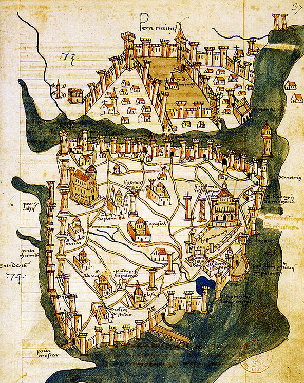
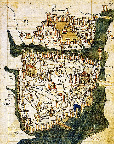
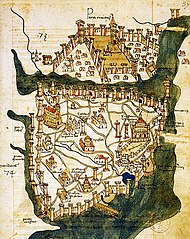
| Danasîn | Map of Constantinople (a small part of modern Istanbul), called "Historic Peninsula", Tarihi Yarımada en Turkish) designed in 1422 by Florentine cartographer Cristoforo Buondelmonti (Description des îles de l'archipel, Bibliothèque nationale, Paris) is the oldest surviving map of the city, and the only surviving map which predates the Turkish conquest of Constantinople in 1453. | ||||
| Dîrok | |||||
| Çavkanî | Liber insularum Archipelagi (1824), version available at the Bibliothèque nationale de France, Paris | ||||
| Xwedî | Cristoforo Buondelmonti | ||||
| Destûr (Dîsa bikaranînê vê dosyeye) |
|
||||
| Guhartoyên din |
|
||||

_by_Florentine_cartographer_Cristoforo_Buondelmonte.jpg?uselang=ku-latn)
Dîroka daneyê
Ji bo dîtina guhartoya wê demê bişkoka dîrokê bitikîne.
| Dîrok/Katjimêr | Wêneyê biçûk | Mezinahî | Bikarhêner | Şirove | |
|---|---|---|---|---|---|
| niha | 10:24, 25 hezîran 2007 | | 592 x 746 (838 KB) | M.K. | {{Information |Description=Map of Constantinople (1422) by Florentine cartographer Cristoforo Buondelmonte (''Description des îles de l'archipel'', Bibliothèque nationale, Paris) is the oldest surviving map of the city, and the only surviving ma |
Bikaranîna pelê
Rûpelekî ku ji vê dosyeyê bi kar tîne nîne.
Bikaranîna gerdûnî ya pelê
Ev wîkiyên di rêzê de vê pelê bi kar tînin:
- Bikaranîna di ar.wikipedia.org de
- Bikaranîna di az.wikipedia.org de
- Bikaranîna di ba.wikipedia.org de
- Bikaranîna di bg.wikipedia.org de
- Bikaranîna di ca.wikipedia.org de
- Bikaranîna di ce.wikipedia.org de
- Bikaranîna di cs.wikipedia.org de
- Bikaranîna di de.wikipedia.org de
- Bikaranîna di el.wikipedia.org de
- Bikaranîna di en.wikipedia.org de
- Bosporus
- Constantinople
- Constantine XI Palaiologos
- John VII Palaiologos
- Walls of Constantinople
- Beyoğlu
- Maiden's Tower
- Siege of Constantinople (1422)
- Siege of Constantinople (1411)
- Template:Did you know nominations/Kontoskalion
- Piyalepaşa, Beyoğlu
- Wikipedia:Main Page history/2019 February 23
- Siege of Constantinople (1394–1402)
- Bikaranîna di es.wikipedia.org de
- Bikaranîna di et.wikipedia.org de
- Bikaranîna di eu.wikipedia.org de
- Bikaranîna di fa.wikipedia.org de
- Bikaranîna di frp.wikipedia.org de
- Bikaranîna di fr.wikipedia.org de
Zêdetir bikaranîna global a vê pelê bibîne.
_by_Florentine_cartographer_Cristoforo_Buondelmonte.jpg)
_by_Florentine_cartographer_Cristoforo_Buondelmonte.jpg)