
Wêne:Ortelius - Maris Pacifici 1589.jpg

Mezinahiya vê pêşdîtinê: 800 × 554 pîksel. Resolusyonên din: 320 × 222 pîksel | 640 × 443 pîksel | 1024 × 709 pîksel | 1280 × 886 pîksel | 2560 × 1773 pîksel | 4001 × 2771 pîksel.
Dosyeya orjînal (4001 × 2771 pixel, mezinbûnê data: 3,81 MB, MIME-typ: image/jpeg)
| Ev pel ji Wikimedia Commonsê ye. Agahdariya li ser rûpela danasîna pelê li jêr tê nîşandan. |
|
Danasîn
| Danasîn |
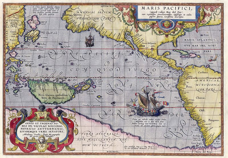
English: Maris Pacifici by Abraham Ortelius. This map was published in 1589 in his Theatrum Orbis Terrarum. It was not only the first printed map of the Pacific, but it also showed the Americas for the first time. Español: Maris Pacifici de Abraham Ortelius. Este mapa fue publicado en 1589 en su Theatrum Orbis Terrarum. No solo fue el primer mapa impreso del Pacífico, sino que también mostró las Américas por primera vez. Bajo la ilustración de la nao Victoria cruzando el Pacífico puede leer lo siguiente en latín: «Prima ego velivovis ambivi cursibus Orbem, Magellane novo te duce ducta freto. Ambivi, meritoque vocor VICTORIA: sunt mî Vela, alæ; precium, gloria: pugna mare» (en español, «Fui la primera en navegar alrededor del mundo por medio de velas, y te llevé a ti, Magallanes, líder, primero a través del estrecho. Navegué alrededor del mundo, por lo tanto, justamente me llamo Victoria, mis velas eran mis alas, mi premio era la gloria, mi lucha era con el mar»). |
|||||||||||||||||||||||
| Dîrok | ||||||||||||||||||||||||
| Çavkanî | Helmink Antique Maps | |||||||||||||||||||||||
| Xwedî |
|
|||||||||||||||||||||||
| Destûr (Dîsa bikaranînê vê dosyeye) |
|
|||||||||||||||||||||||
| Guhartoyên din |
|
|||||||||||||||||||||||


Dîroka daneyê
Ji bo dîtina guhartoya wê demê bişkoka dîrokê bitikîne.
| Dîrok/Katjimêr | Wêneyê biçûk | Mezinahî | Bikarhêner | Şirove | |
|---|---|---|---|---|---|
| niha | 15:50, 5 gulan 2007 | | 4001 x 2771 (3,81 MB) | Jan Arkesteijn | {{Information |Description=Maris Pacifici by Abraham Ortelius |Source=[http://www.helmink.com/Antique_Map_Ortelius_Pacific/ Helmink Antique Maps] |Date=1589 |Author=Abraham Ortelius }} This map was published in 1589 in his 'Theatrum Orbis Terrarum'. It w |
Bikaranîna pelê
Rûpelekî ku ji vê dosyeyê bi kar tîne nîne.
Bikaranîna gerdûnî ya pelê
Ev wîkiyên di rêzê de vê pelê bi kar tînin:
- Bikaranîna di als.wikipedia.org de
- Bikaranîna di ar.wikipedia.org de
- Bikaranîna di azb.wikipedia.org de
- Bikaranîna di az.wikipedia.org de
- Bikaranîna di bcl.wikipedia.org de
- Bikaranîna di be.wikipedia.org de
- Bikaranîna di bn.wikipedia.org de
- Bikaranîna di bo.wikipedia.org de
- Bikaranîna di ca.wikipedia.org de
- Bikaranîna di ckb.wikipedia.org de
- Bikaranîna di da.wikipedia.org de
- Bikaranîna di de.wikipedia.org de
- Bikaranîna di en.wikipedia.org de
- Pacific Ocean
- Abraham Ortelius
- Theatrum Orbis Terrarum
- Portal:Maps/Selected picture
- Wikipedia:Featured pictures thumbs/11
- Wikipedia:Featured picture candidates/March-2008
- Wikipedia:Featured picture candidates/File:Ortelius - Maris Pacifici 1589.jpg
- Wikipedia:Wikipedia Signpost/2008-03-31/Features and admins
- Wikipedia:Featured pictures/Diagrams, drawings, and maps/Maps
- Maris Pacifici
- User talk:Paulcmnt/Archive 1
- Wikipedia:Wikipedia Signpost/2008-03-31/SPV
- Wikipedia:Picture of the day/October 2008
- Template:POTD/2008-10-23
- Portal:Maps/Selected picture/50
- Wikipedia:Graphics Lab/Photography workshop/Archive/Jul 2010
- Portal:Maps
- Portal:Oceans
- Wikipedia:Contents/gallery2
- Wikipedia:Wikipedia Signpost/Single/2008-03-31
- Bikaranîna di es.wikipedia.org de
- Bikaranîna di fr.wikipedia.org de
- Bikaranîna di fr.wikiversity.org de
- Bikaranîna di fy.wikipedia.org de
- Bikaranîna di gcr.wikipedia.org de
- Bikaranîna di gl.wikipedia.org de
- Bikaranîna di he.wikipedia.org de
- Bikaranîna di hi.wikipedia.org de
- Bikaranîna di hu.wikipedia.org de
Zêdetir bikaranîna global a vê pelê bibîne.