
Wêne:World 1914 empires colonies territory.PNG

Mezinahiya vê pêşdîtinê: 800 × 330 pîksel. Resolusyonên din: 320 × 132 pîksel | 640 × 264 pîksel | 1522 × 628 pîksel.
Dosyeya orjînal (1522 × 628 pixel, mezinbûnê data: 45 KB, MIME-typ: image/png)
| Ev pel ji Wikimedia Commonsê ye. Agahdariya li ser rûpela danasîna pelê li jêr tê nîşandan. |

|
This map image could be re-created using vector graphics as an SVG file. This has several advantages; see Commons:Media for cleanup for more information. If an SVG form of this image is available, please upload it and afterwards replace this template with
{{vector version available|new image name}}.
It is recommended to name the SVG file “World 1914 empires colonies territory.svg”—then the template Vector version available (or Vva) does not need the new image name parameter. |
Danasîn
| Danasîn |
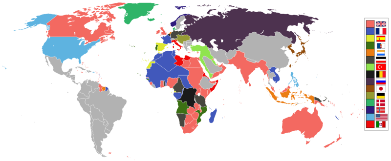
English: World empires and colonies in 1914, just before the First World War.
|
||||||||||||||||
| Dîrok | |||||||||||||||||
| Çavkanî | Min çêkir | ||||||||||||||||
| Xwedî | Andrew0921 | ||||||||||||||||
.jpg)
._LOC_2001620596.jpg)
British Empire
France
Spain
Portugal
Netherlands
German Empire
Ottoman
Belgium
Russia
Japan
Denmark
Norway
United States of America
Italy
Independent/other countries
Lîsans
I, the copyright holder of this work, hereby publish it under the following license:
This file is licensed under the Creative Commons Attribution 3.0 Unported license.
- Tu azad î:
- parve bike – ji bo kopîkirin, belavkirin û weşandina xebatê
- ji bo guhartin û adaptekirina naverokê – ji bo adaptekirina xebatê
- Di bin van mercan de:
- isnad – Divê tu isnadeke maqûl bikî, lînekek pêşkêş bikî ji bo lîsansê, û diyar bikî ku guhartin hatiye kirin an na. Tu dikarî vê yekê bi adilî bi cih bînî, lê ne bi awayê ku wekî lîsansor te an bikaranîna te pejirandibe.
Dîroka daneyê
Ji bo dîtina guhartoya wê demê bişkoka dîrokê bitikîne.
| Dîrok/Katjimêr | Wêneyê biçûk | Mezinahî | Bikarhêner | Şirove | |
|---|---|---|---|---|---|
| niha | 09:28, 8 çiriya paşîn 2021 | | 1522 x 628 (45 KB) | Randomastwritter | jubaland |
| 00:00, 14 nîsan 2021 |  | 1522 x 628 (45 KB) | Offa29 | Fixed Togoland colour | |
| 18:57, 24 nîsan 2020 |  | 1522 x 628 (45 KB) | The- | Norwegian flag | |
| 17:08, 24 nîsan 2020 |  | 1522 x 628 (45 KB) | The- | If an old map with wrongly drawn borders is replaced with a better map wth a minor colour error, then fix that minor colour error. Don't just blithely revert to the bad old map. | |
| 21:52, 17 adar 2020 |  | 1474 x 620 (36 KB) | Makkkkus | Replaced the Swedish-Norwegian union flag with the Norwegian flag. | |
| 19:25, 13 adar 2020 |  | 1474 x 620 (22 KB) | Morris-frank | The new version introduced a big regression (coloring spain in the color of italy), also it did not contribute anything useful. | |
| 21:49, 14 tebax 2019 |  | 1522 x 628 (45 KB) | The- | More accurate map | |
| 12:47, 5 tîrmeh 2016 |  | 1474 x 620 (22 KB) | Maproom | Removed borders between provinces of Australia, as requested at https://en.wikipedia.org/wiki/Wikipedia:Graphics_Lab/Map_workshop#FIFA_World_Cup_Maps_-_Colonial_Boundaries , because it had been united into a single dominion before 1914. | |
| 00:00, 26 kanûna pêşîn 2010 |  | 1474 x 620 (33 KB) | Quigley | by 1914, Qing Dynasty had collapsed and Republic of China established | |
| 13:56, 22 çiriya paşîn 2010 |  | 1474 x 620 (20 KB) | AnonMoos | cropping margins, increasing PNG compression |
Bikaranîna pelê
Rûpelekî ku ji vê dosyeyê bi kar tîne nîne.
Bikaranîna gerdûnî ya pelê
Ev wîkiyên di rêzê de vê pelê bi kar tînin:
- Bikaranîna di af.wikipedia.org de
- Bikaranîna di ar.wikipedia.org de
- Bikaranîna di azb.wikipedia.org de
- Bikaranîna di bn.wikipedia.org de
- Bikaranîna di ca.wikipedia.org de
- Bikaranîna di da.wikipedia.org de
- Bikaranîna di en.wikipedia.org de
- Bikaranîna di eo.wikipedia.org de
- Bikaranîna di eo.wikiquote.org de
- Bikaranîna di es.wikipedia.org de
- Bikaranîna di fa.wikipedia.org de
- Bikaranîna di fi.wikipedia.org de
- Bikaranîna di fr.wikipedia.org de
- Bikaranîna di fy.wikipedia.org de
- Bikaranîna di gl.wikipedia.org de
- Bikaranîna di hu.wikipedia.org de
- Bikaranîna di it.wikipedia.org de
- Bikaranîna di ja.wikipedia.org de
- Bikaranîna di jv.wikipedia.org de
- Bikaranîna di ka.wikipedia.org de
- Bikaranîna di lv.wikipedia.org de
- Bikaranîna di mk.wikipedia.org de
- Bikaranîna di ml.wikipedia.org de
- Bikaranîna di oc.wikipedia.org de
- Bikaranîna di pt.wikipedia.org de
- Bikaranîna di ro.wikipedia.org de
Zêdetir bikaranîna global a vê pelê bibîne.