
Wêne:Bairisches Mundartgebiet.PNG
Mezinahiya vê pêşdîtinê: 800 × 505 pîksel. Resolusyonên din: 320 × 202 pîksel | 640 × 404 pîksel | 1031 × 651 pîksel.
Dosyeya orjînal (1031 × 651 pixel, mezinbûnê data: 43 KB, MIME-typ: image/png)
| Ev pel ji Wikimedia Commonsê ye. Agahdariya li ser rûpela danasîna pelê li jêr tê nîşandan. |

|
This linguistic map image could be re-created using vector graphics as an SVG file. This has several advantages; see Commons:Media for cleanup for more information. If an SVG form of this image is available, please upload it and afterwards replace this template with
{{vector version available|new image name}}.
It is recommended to name the SVG file “Bairisches Mundartgebiet.svg”—then the template Vector version available (or Vva) does not need the new image name parameter. |
Danasîn
العربية (ar): انتشار اللهجات البافارية الحديثة:
البافارية الشمالية (البالانتية العليا).
البافارية الوسطى (البافارية الدانوبية).
البافارية الجنوبية (البافارية الألبية).
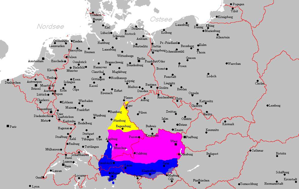
Deutsch (de): Verbreitungsgebiet der heutigen bairischen Mundarten
Nordbairisch
Mittel- oder Donaubairisch
Südbairisch
English (en): Prevalence of modern Bavarian dialects
North Bavarian
Central or Danube Bavarian
South Bavarian
русский (ru): Современные ареалы распространения баварских диалектов
жёлтый: северо-баварский
розовый: среднебаварский (австро (дунайско)-баварский)
синий: южно-баварский
español (es): Distribución del Bavariano.
Baviera del Norte
Baviera central o del Danubio
Baviera del Sur
- design by: Postmann Michael
- Quelle: Selbst erstellt.
- Hinweis: Nach den Vorgaben des "Der Fischer-Informationsatlas der Bundesrepublik Deutschland" (ISBN 3-596-24556-4 Invalid ISBN) von 1990 (S. 63) selbst erstellt. Es wurde sowohl die Karte Westmitteleuropas als auch das bayrische Sprachgebiet vom Autor händisch erstellt. Diese Karte ist gemeinfrei und darf von jedermann verwendet werden!
- Source: Self-made.
- Notes: Information derived from "The Fischer Information Atlas of the Federal Republic of Germany" (ISBN 3-596-24556-4 Invalid ISBN) from 1990 (P. 63). Both the map of west Central Europe and the Bavarian language area were by hand provided by the author. This map is in the public domain and may be used by everyone!
Lîsans
| This work has been released into the public domain by its author, Postmann Michael. This applies worldwide. In some countries this may not be legally possible; if so: |
Dîroka daneyê
Ji bo dîtina guhartoya wê demê bişkoka dîrokê bitikîne.
| Dîrok/Katjimêr | Wêneyê biçûk | Mezinahî | Bikarhêner | Şirove | |
|---|---|---|---|---|---|
| niha | 21:22, 18 sibat 2012 | | 1031 x 651 (43 KB) | Buachamer | Sechsämterland und Südvogtland hinzugefügt (siehe http://bar.wikipedia.org/wiki/Datei:Bairischer_Sprachraum2.PNG) |
| 17:56, 12 nîsan 2009 |  | 1031 x 651 (57 KB) | Altaileopard | Nürnberg aus dem bayerischen Dialektraum entfernt. | |
| 04:10, 2 adar 2006 |  | 1031 x 651 (57 KB) | Postmann Michael~commonswiki |
Bikaranîna pelê
Ev rûpelên li jêr vê dosyeyê bi kar tînin:
Bikaranîna gerdûnî ya pelê
Ev wîkiyên di rêzê de vê pelê bi kar tînin:
- Bikaranîna di als.wikipedia.org de
- Bikaranîna di ar.wikipedia.org de
- Bikaranîna di ast.wikipedia.org de
- Bikaranîna di be-tarask.wikipedia.org de
- Bikaranîna di be.wikipedia.org de
- Bikaranîna di bg.wikipedia.org de
- Bikaranîna di br.wikipedia.org de
- Bikaranîna di ca.wikipedia.org de
- Bikaranîna di cs.wikipedia.org de
- Bikaranîna di da.wikipedia.org de
- Bikaranîna di de.wikipedia.org de
- Bikaranîna di de.wiktionary.org de
- Bikaranîna di en.wikipedia.org de
- Bikaranîna di es.wikipedia.org de
- Bikaranîna di et.wikipedia.org de
- Bikaranîna di eu.wikipedia.org de
- Bikaranîna di fa.wikipedia.org de
- Bikaranîna di fr.wikipedia.org de
- Bikaranîna di fy.wikipedia.org de
- Bikaranîna di ga.wikipedia.org de
- Bikaranîna di hak.wikipedia.org de
- Bikaranîna di he.wikipedia.org de
- Bikaranîna di id.wikipedia.org de
- Bikaranîna di incubator.wikimedia.org de
- Bikaranîna di it.wikipedia.org de
Zêdetir bikaranîna global a vê pelê bibîne.