
Wêne:Cities in China.png
Mezinahiya vê pêşdîtinê: 759 × 600 pîksel. Resolusyonên din: 304 × 240 pîksel | 607 × 480 pîksel | 972 × 768 pîksel | 1280 × 1012 pîksel | 2560 × 2023 pîksel | 6246 × 4937 pîksel.
Dosyeya orjînal (6246 × 4937 pixel, mezinbûnê data: 895 KB, MIME-typ: image/png)
| Ev pel ji Wikimedia Commonsê ye. Agahdariya li ser rûpela danasîna pelê li jêr tê nîşandan. |

|
This image is expected to always be the most recent one. Feel free to update it when needed.
|

|
This file may be updated to reflect new information. If you wish to use a specific version of the file without new updates being mirrored, please upload the required version as a separate file. |
Danasîn
| Danasîn |
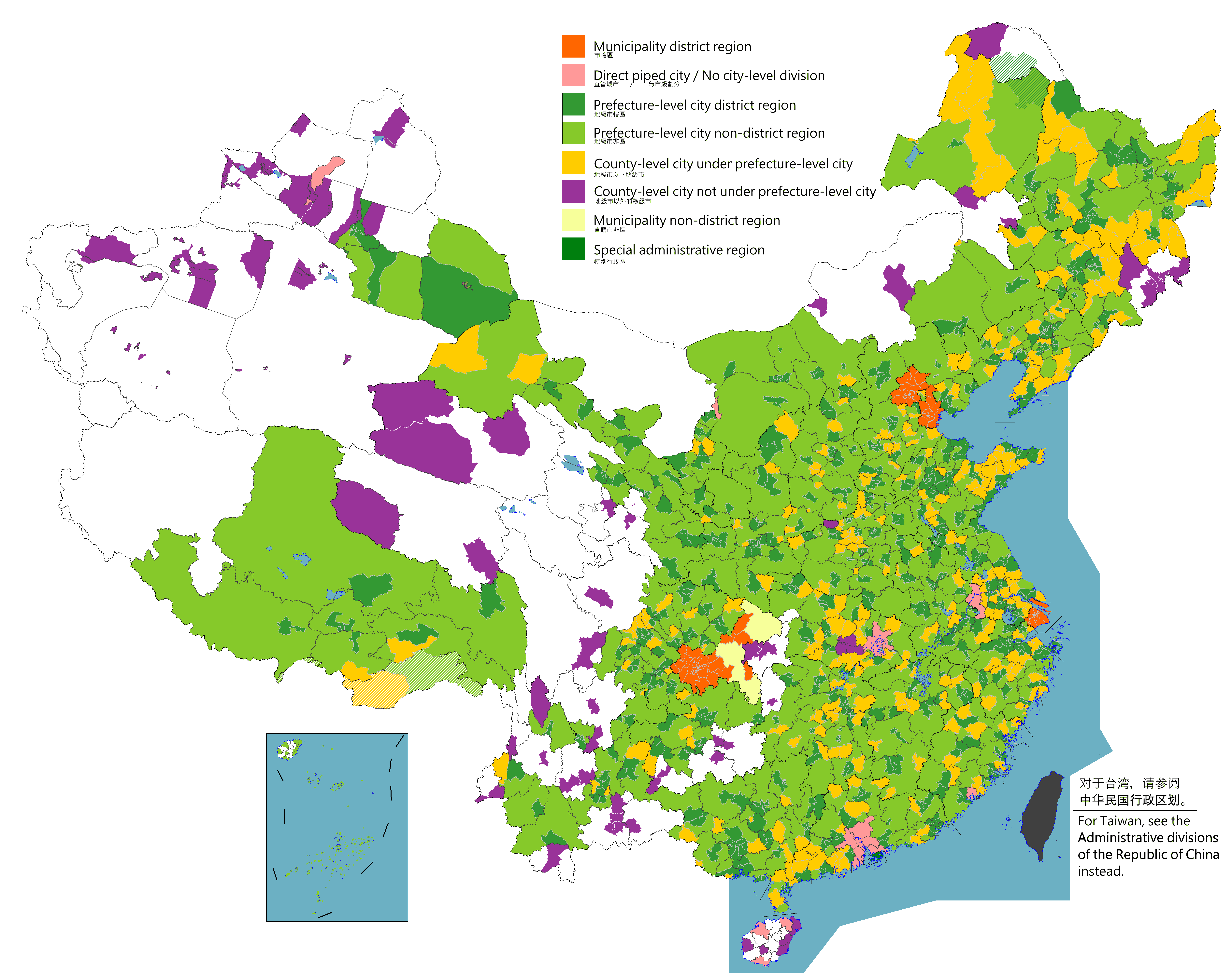
English: Map of China's types of cities.
日本語: 中国の都市の種類の地図。
Русский: Карта типов городов Китая.
Монгол: Хятадын төрлийн хотуудын газрын зураг.
中文(简体):中国城市类型图。(包含未實際控制之疆域)
中文(繁體):中國城市類型圖。 (包含未實際控制之疆域) |
||
| Dîrok |
|
||
| Çavkanî |
Legend: Municipality district region
Direct piped city / No city-level division
Prefecture-level city district region
Prefecture-level city non-district region
County-level city under prefecture-level city
County-level city not prefecture-level city
Municipality non-district region
Special administrative region
Source appearances:
[]
|
||
| Xwedî |
|
||
| Destûr (Dîsa bikaranînê vê dosyeye) |
Map of China, types of cities: I, the copyright holder of this work, hereby publish it under the following license:
|
.png)
.png)
Lîsans
I, the copyright holder of this work, hereby publish it under the following license:
This file is licensed under the Creative Commons Attribution-Share Alike 4.0 International license.
- Tu azad î:
- parve bike – ji bo kopîkirin, belavkirin û weşandina xebatê
- ji bo guhartin û adaptekirina naverokê – ji bo adaptekirina xebatê
- Di bin van mercan de:
- isnad – Divê tu isnadeke maqûl bikî, lînekek pêşkêş bikî ji bo lîsansê, û diyar bikî ku guhartin hatiye kirin an na. Tu dikarî vê yekê bi adilî bi cih bînî, lê ne bi awayê ku wekî lîsansor te an bikaranîna te pejirandibe.
- parvekirinê mîna hev – Ger tu materyalê biguherînî, bizivirînî formeke din, an ava bikî divê beşdariyên xwe di bin eynî lîsansê an lîsansa hevaheng de wekî ya eslî belav bikî.

|
This locator map image could be re-created using vector graphics as an SVG file. This has several advantages; see Commons:Media for cleanup for more information. If an SVG form of this image is available, please upload it and afterwards replace this template with
{{vector version available|new image name}}.
It is recommended to name the SVG file “Cities in China.svg”—then the template Vector version available (or Vva) does not need the new image name parameter. |
|
|
This map image could be re-created using vector graphics as an SVG file. This has several advantages; see Commons:Media for cleanup for more information. If an SVG form of this image is available, please upload it and afterwards replace this template with
{{vector version available|new image name}}.
It is recommended to name the SVG file “Cities in China.svg”—then the template Vector version available (or Vva) does not need the new image name parameter. |
| Annotations | This image is annotated: View the annotations at Commons |
Dîroka daneyê
Ji bo dîtina guhartoya wê demê bişkoka dîrokê bitikîne.
| Dîrok/Katjimêr | Wêneyê biçûk | Mezinahî | Bikarhêner | Şirove | |
|---|---|---|---|---|---|
| niha | 10:09, 2 tebax 2023 | | 6246 x 4937 (895 KB) | Maanshen | |
| 09:59, 2 tebax 2023 |  | 6246 x 4937 (897 KB) | Maanshen | ||
| 09:51, 2 tebax 2023 |  | 6246 x 4937 (893 KB) | Maanshen | ||
| 08:59, 1 tebax 2023 |  | 6246 x 4937 (891 KB) | Maanshen | ||
| 23:06, 2 tebax 2022 |  | 6246 x 4937 (901 KB) | Maanshen | Update disputed/claimed borders, white with stroke is not claimed and filled in color is claimed | |
| 00:08, 20 nîsan 2022 |  | 6246 x 4937 (893 KB) | Maanshen | Fix borders between Ili's Kuytun, Huyanghe, and Karamay | |
| 01:45, 31 adar 2022 |  | 6246 x 4937 (893 KB) | Maanshen | Fix some colors | |
| 00:59, 29 adar 2022 |  | 6246 x 4937 (893 KB) | Maanshen | Fix colors in Shanxi with Fenyang and Xiaoyi | |
| 01:00, 17 adar 2022 |  | 6246 x 4937 (893 KB) | Maanshen | Fix Dongtai as a county-level city | |
| 03:51, 1 adar 2022 |  | 6246 x 4937 (893 KB) | Maanshen | Update Shanghai land reclamation and cpunty border changes as of 2022 |
Bikaranîna pelê
Ev rûpelên li jêr vê dosyeyê bi kar tînin:
Bikaranîna gerdûnî ya pelê
Ev wîkiyên di rêzê de vê pelê bi kar tînin:
- Bikaranîna di en.wikipedia.org de
- Bikaranîna di fi.wikipedia.org de
- Bikaranîna di id.wikipedia.org de
- Bikaranîna di ilo.wikipedia.org de
- Bikaranîna di ko.wikipedia.org de
- Bikaranîna di mk.wikipedia.org de
- Bikaranîna di mn.wikipedia.org de
- Bikaranîna di ne.wikipedia.org de
- Bikaranîna di th.wikipedia.org de
- Bikaranîna di tr.wikipedia.org de
- Bikaranîna di uz.wikipedia.org de
- Bikaranîna di zh.wikipedia.org de