
Wêne:Kingdom of Hungary counties.svg

Size of this PNG preview of this SVG file: 779 × 513 pîksel. Resolusyonên din: 320 × 211 pîksel | 640 × 421 pîksel | 1024 × 674 pîksel | 1280 × 843 pîksel | 2560 × 1686 pîksel.
Dosyeya orjînal (Daneya SVG, mezinbûna rast: 779 × 513 pixel; mezinbûna daneyê: 235 KB)
| Ev pel ji Wikimedia Commonsê ye. Agahdariya li ser rûpela danasîna pelê li jêr tê nîşandan. |
Danasîn
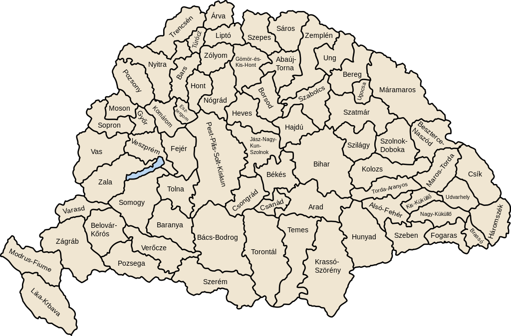
| Danasîn | Map of counties of Kingdom of Hungary (Hungary proper and Croatia & Slavonia), 1886-1918 |
| Dîrok | |
| Çavkanî | Min çêkir |
| Xwedî | User:IMeowbot |
| Guhartoyên din | Derivative works of this file: Kingdom of Hungary counties-2.svg |
| SVG development | W3C-validity not checked. |
Lîsans
| I, the copyright holder of this work, release this work into the public domain. This applies worldwide. In some countries this may not be legally possible; if so: I grant anyone the right to use this work for any purpose, without any conditions, unless such conditions are required by law. |
Dîroka daneyê
Ji bo dîtina guhartoya wê demê bişkoka dîrokê bitikîne.
| Dîrok/Katjimêr | Wêneyê biçûk | Mezinahî | Bikarhêner | Şirove | |
|---|---|---|---|---|---|
| niha | 07:41, 19 tîrmeh 2023 | | 779 x 513 (235 KB) | Alphathon | Reverted to version as of 22:47, 16 August 2022 (UTC). Bars/Hont and Csongrád/Bács-Bodrog borders are inaccurate, several more are distored (most only slightly) and the file is a "FakeSVG" – a raster image using an SVG as a container with no actual vector elements. |
| 22:43, 20 kanûna paşîn 2023 |  | 8277 x 5472 (589 KB) | Ascended Dreamer | Added FIume and increased line weight | |
| 22:31, 20 kanûna paşîn 2023 |  | 8277 x 5472 (607 KB) | Ascended Dreamer | Increased border accuracy | |
| 22:47, 16 tebax 2022 |  | 779 x 513 (235 KB) | Alphathon | corrected õ → ő (tilde → double accute) | |
| 17:53, 5 kanûna pêşîn 2009 |  | 779 x 513 (235 KB) | SimonTrew | Fix spelling error Veszprém. | |
| 14:24, 3 kanûna pêşîn 2009 |  | 779 x 513 (235 KB) | SimonTrew | Fixed spelling of "Poszsony" -> "Pozsony". | |
| 20:25, 20 tebax 2007 |  | 779 x 513 (235 KB) | Xavax | == Summary == {{Information| |Description= Map of counties of Hungary with Croatia & Slavonia, 1886-1918 |Source=own drawing |Date=April 30, 2006 |Author=User:IMeowbot |Permission= |other_versions= }} == Licensing == {{PD-self}} <!--Categories--> [[ | |
| 22:10, 30 nîsan 2006 |  | 779 x 513 (223 KB) | IMeowbot~commonswiki | line weight | |
| 21:34, 30 nîsan 2006 |  | 779 x 513 (221 KB) | IMeowbot~commonswiki | ||
| 18:34, 30 nîsan 2006 |  | 779 x 513 (195 KB) | IMeowbot~commonswiki | {{Information| |Description= Map of late 1870s Hungary counties |Source=own drawing |Date=April 30, 2006 |Author=User:IMeowbot |Permission= |other_versions= }} |
Bikaranîna pelê
Ev rûpelên li jêr vê dosyeyê bi kar tînin:
Bikaranîna gerdûnî ya pelê
Ev wîkiyên di rêzê de vê pelê bi kar tînin:
- Bikaranîna di als.wikipedia.org de
- Bikaranîna di an.wikipedia.org de
- Bikaranîna di ar.wikipedia.org de
- Bikaranîna di azb.wikipedia.org de
- Bikaranîna di bg.wikipedia.org de
- Bikaranîna di bn.wikipedia.org de
- Bikaranîna di ca.wikipedia.org de
- Bikaranîna di cs.wikipedia.org de
- Bikaranîna di cy.wikipedia.org de
- Bikaranîna di de.wikipedia.org de
- Bikaranîna di el.wikipedia.org de
- Bikaranîna di en.wikipedia.org de
- Liptó County
- Zemplén County
- Hont County
- Bars County
- Turóc County
- Brassó County
- Bihar County
- Kingdom of Hungary
- Esztergom County
- Pozsony County
- Nyitra County
- Moson County
- Sopron County
- Bács-Bodrog County
- Heves County (former)
- Jász-Nagykun-Szolnok County (former)
- Trencsén County
- Zólyom County
- Pest-Pilis-Solt-Kiskun County
- Komárom County
- Bereg County
- Borsod County
- Ung County
- Hajdú County
- Máramaros County
- Szabolcs County
- Szatmár County
Zêdetir bikaranîna global a vê pelê bibîne.