
Wêne:Location of the Kingdom of Asturias.PNG
Versyonekî jê mezintir tune.
Location_of_the_Kingdom_of_Asturias.PNG (250 × 115 pixel, mezinbûnê data: 5 KB, MIME-typ: image/png)
| Ev pel ji Wikimedia Commonsê ye. Agahdariya li ser rûpela danasîna pelê li jêr tê nîşandan. |
| I, the copyright holder of this work, release this work into the public domain. This applies worldwide. In some countries this may not be legally possible; if so: I grant anyone the right to use this work for any purpose, without any conditions, unless such conditions are required by law. |
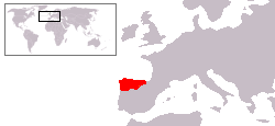
Mapa aproximado del Reino de Asturias en su apogeo.
Basado en Image:Location of the Kingdom of Scotland.PNG y Image:Península ibérica 814.svg
Dîroka daneyê
Ji bo dîtina guhartoya wê demê bişkoka dîrokê bitikîne.
| Dîrok/Katjimêr | Wêneyê biçûk | Mezinahî | Bikarhêner | Şirove | |
|---|---|---|---|---|---|
| niha | 04:42, 19 hezîran 2009 | | 250 x 115 (5 KB) | AlGarcia | Correción. |
| 10:46, 1 sibat 2009 |  | 250 x 115 (5 KB) | AlGarcia | ||
| 16:19, 27 tîrmeh 2006 |  | 250 x 115 (5 KB) | AlGarcia | {{PD-self/es}} Mapa aproximado del Reino de Asturias en su apogeo. Basado en Image:Location of the Kingdom of Scotland.PNG Category:Locator maps for former territories Category:Maps of the history of Spain Category:Asturias |
Bikaranîna pelê
Ev rûpelên li jêr vê dosyeyê bi kar tînin:
Bikaranîna gerdûnî ya pelê
Ev wîkiyên di rêzê de vê pelê bi kar tînin:
- Bikaranîna di an.wikipedia.org de
- Bikaranîna di ar.wikipedia.org de
- Bikaranîna di arz.wikipedia.org de
- Bikaranîna di ast.wikipedia.org de
- Bikaranîna di be.wikipedia.org de
- Bikaranîna di bg.wikipedia.org de
- Bikaranîna di ca.wikipedia.org de
- Bikaranîna di de.wikipedia.org de
- Bikaranîna di eo.wikipedia.org de
- Bikaranîna di et.wikipedia.org de
- Bikaranîna di eu.wikipedia.org de
- Bikaranîna di fa.wikipedia.org de
- Bikaranîna di fr.wikipedia.org de
- Bikaranîna di fy.wikipedia.org de
- Bikaranîna di ga.wikipedia.org de
- Bikaranîna di gl.wikipedia.org de
- Bikaranîna di hr.wikipedia.org de
- Bikaranîna di hy.wikipedia.org de
- Bikaranîna di ia.wikipedia.org de
- Bikaranîna di io.wikipedia.org de
- Bikaranîna di la.wikipedia.org de
- Bikaranîna di li.wikipedia.org de
- Bikaranîna di lt.wikipedia.org de
- Bikaranîna di nl.wikipedia.org de
- Bikaranîna di no.wikipedia.org de
- Bikaranîna di oc.wikipedia.org de
- Bikaranîna di pnb.wikipedia.org de
- Bikaranîna di ro.wikipedia.org de
- Bikaranîna di sco.wikipedia.org de
- Bikaranîna di sh.wikipedia.org de
- Bikaranîna di tr.wikipedia.org de
- Bikaranîna di ur.wikipedia.org de
- Bikaranîna di www.wikidata.org de
- Bikaranîna di zh.wikipedia.org de