
Wêne:Mairie-montret-2012.JPG

Mezinahiya vê pêşdîtinê: 800 × 600 pîksel. Resolusyonên din: 320 × 240 pîksel | 640 × 480 pîksel | 1024 × 768 pîksel | 1280 × 960 pîksel | 1600 × 1200 pîksel.
Dosyeya orjînal (1600 × 1200 pixel, mezinbûnê data: 572 KB, MIME-typ: image/jpeg)
| Ev pel ji Wikimedia Commonsê ye. Agahdariya li ser rûpela danasîna pelê li jêr tê nîşandan. |
Danasîn
| Şûnda kamerayê | | Ev wêne û yên din li ser OpenStreetMap |
|---|
| Danasîn |
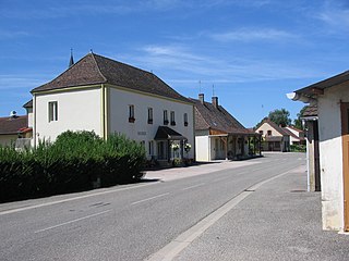
Français : La mairie du village de Montret (Saône-et-Loire, Bourgogne, France) photographiée en juillet 2012. |
| Dîrok | |
| Çavkanî | Min çêkir |
| Xwedî | Elli32713 |
Lîsans
I, the copyright holder of this work, hereby publish it under the following license:
| This file is made available under the Creative Commons CC0 1.0 Universal Public Domain Dedication. | |
| The person who associated a work with this deed has dedicated the work to the public domain by waiving all of their rights to the work worldwide under copyright law, including all related and neighboring rights, to the extent allowed by law. You can copy, modify, distribute and perform the work, even for commercial purposes, all without asking permission.
|
Dîroka daneyê
Ji bo dîtina guhartoya wê demê bişkoka dîrokê bitikîne.
| Dîrok/Katjimêr | Wêneyê biçûk | Mezinahî | Bikarhêner | Şirove | |
|---|---|---|---|---|---|
| niha | 14:16, 23 tîrmeh 2012 | | 1600 x 1200 (572 KB) | Elli32713 |
Bikaranîna pelê
Ev rûpelên li jêr vê dosyeyê bi kar tînin:
Bikaranîna gerdûnî ya pelê
Ev wîkiyên di rêzê de vê pelê bi kar tînin:
- Bikaranîna di ast.wikipedia.org de
- Bikaranîna di ca.wikipedia.org de
- Bikaranîna di ceb.wikipedia.org de
- Bikaranîna di ce.wikipedia.org de
- Bikaranîna di el.wikipedia.org de
- Bikaranîna di en.wikipedia.org de
- Bikaranîna di es.wikipedia.org de
- Bikaranîna di eu.wikipedia.org de
- Bikaranîna di fr.wikipedia.org de
- Bikaranîna di hu.wikipedia.org de
- Bikaranîna di it.wikipedia.org de
- Bikaranîna di la.wikipedia.org de
- Bikaranîna di nl.wikipedia.org de
- Bikaranîna di oc.wikipedia.org de
- Bikaranîna di pl.wikipedia.org de
- Bikaranîna di pt.wikipedia.org de
- Bikaranîna di ro.wikipedia.org de
- Bikaranîna di sk.wikipedia.org de
- Bikaranîna di sv.wikipedia.org de
- Bikaranîna di uk.wikipedia.org de
- Bikaranîna di uz.wikipedia.org de
- Bikaranîna di vec.wikipedia.org de
- Bikaranîna di www.wikidata.org de
- Bikaranîna di zh-min-nan.wikipedia.org de
- Bikaranîna di zh.wikipedia.org de