
Wêne:Map of USA AK full.png
Versyonekî jê mezintir tune.
Map_of_USA_AK_full.png (284 × 184 pixel, mezinbûnê data: 19 KB, MIME-typ: image/png)
| Ev pel ji Wikimedia Commonsê ye. Agahdariya li ser rûpela danasîna pelê li jêr tê nîşandan. |

|
File:Map of USA AK full.svg is a vector version of this file. It should be used in place of this PNG file when not inferior.
File:Map of USA AK full.png → File:Map of USA AK full.svg
For more information, see Help:SVG. |
 |
Danasîn
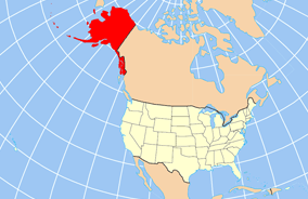
| Danasîn | Map of USA with Alaska highlighted and shown in true position |
| Dîrok | |
| Çavkanî | http://www.nationalatlas.gov/printable/reference.html |
| Xwedî | |
| Guhartoyên din | File:Map of USA AK full.svg |
Lîsans
This map was obtained from an edition of the National Atlas of the United States. Like almost all works of the U.S. federal government, works from the National Atlas are in the public domain in the United States.
Online access: NationalAtlas.gov | 1970 print edition: Library of Congress, Perry-Castañeda Library
|
Dîroka daneyê
Ji bo dîtina guhartoya wê demê bişkoka dîrokê bitikîne.
| Dîrok/Katjimêr | Wêneyê biçûk | Mezinahî | Bikarhêner | Şirove | |
|---|---|---|---|---|---|
| niha | 20:43, 17 kanûna pêşîn 2012 | | 284 x 184 (19 KB) | Ras67 | cropped |
| 16:31, 2 nîsan 2007 |  | 286 x 186 (20 KB) | MattWright | fix to more standard map colors | |
| 06:20, 2 nîsan 2007 |  | 286 x 186 (19 KB) | MattWright | {{Information |Description=Map of USA with Alaska highlighted and shown in true position |Source=http://www.nationalatlas.gov/printable/reference.html |Date=2007-04-02 |Author= |Permission= |other_versions= }} Category:Maps of the United States [[Cat |
Bikaranîna pelê
Rûpelekî ku ji vê dosyeyê bi kar tîne nîne.
Bikaranîna gerdûnî ya pelê
Ev wîkiyên di rêzê de vê pelê bi kar tînin:
- Bikaranîna di am.wikipedia.org de
- Bikaranîna di ar.wikipedia.org de
- Bikaranîna di az.wikipedia.org de
- Bikaranîna di az.wiktionary.org de
- Bikaranîna di ba.wikipedia.org de
- Bikaranîna di bn.wikipedia.org de
- Bikaranîna di ce.wikipedia.org de
- Bikaranîna di cy.wikipedia.org de
- Bikaranîna di da.wikipedia.org de
- Bikaranîna di de.wikipedia.org de
- Bikaranîna di el.wikipedia.org de
- Bikaranîna di en.wikipedia.org de
- Bikaranîna di es.wikibooks.org de
- Bikaranîna di fa.wikipedia.org de
- Bikaranîna di fr.wikinews.org de
- Bikaranîna di ga.wikipedia.org de
- Sitka
- Buirg Aleutians Thoir, Alasca
- Buirg Anchorage, Alasca
- Buirg Artach Thiar Thuaidh, Alasca
- Buirg Bristol Bay, Alasca
- Buirg Denali, Alasca
- Buirg Fairbanks Réalta Thuaidh, Alasca
- Buirg Haines, Alasca
- Buirg Juneau, Alasca
- Buirg Leithinis Kenai, Alasca
- Buirg Tairseach Ketchikan, Alasca
- Buirg Oileán Kodiak, Alasca
- Buirg Loch agus Leithinis, Alasca
- Buirg Matanuska-Susitna, Alasca
Zêdetir bikaranîna global a vê pelê bibîne.