
Wêne:ShepherdByzempire1265.jpg
Dosyeya orjînal (1144 × 900 pixel, mezinbûnê data: 281 KB, MIME-typ: image/jpeg)
| Ev pel ji Wikimedia Commonsê ye. Agahdariya li ser rûpela danasîna pelê li jêr tê nîşandan. |
Danasîn
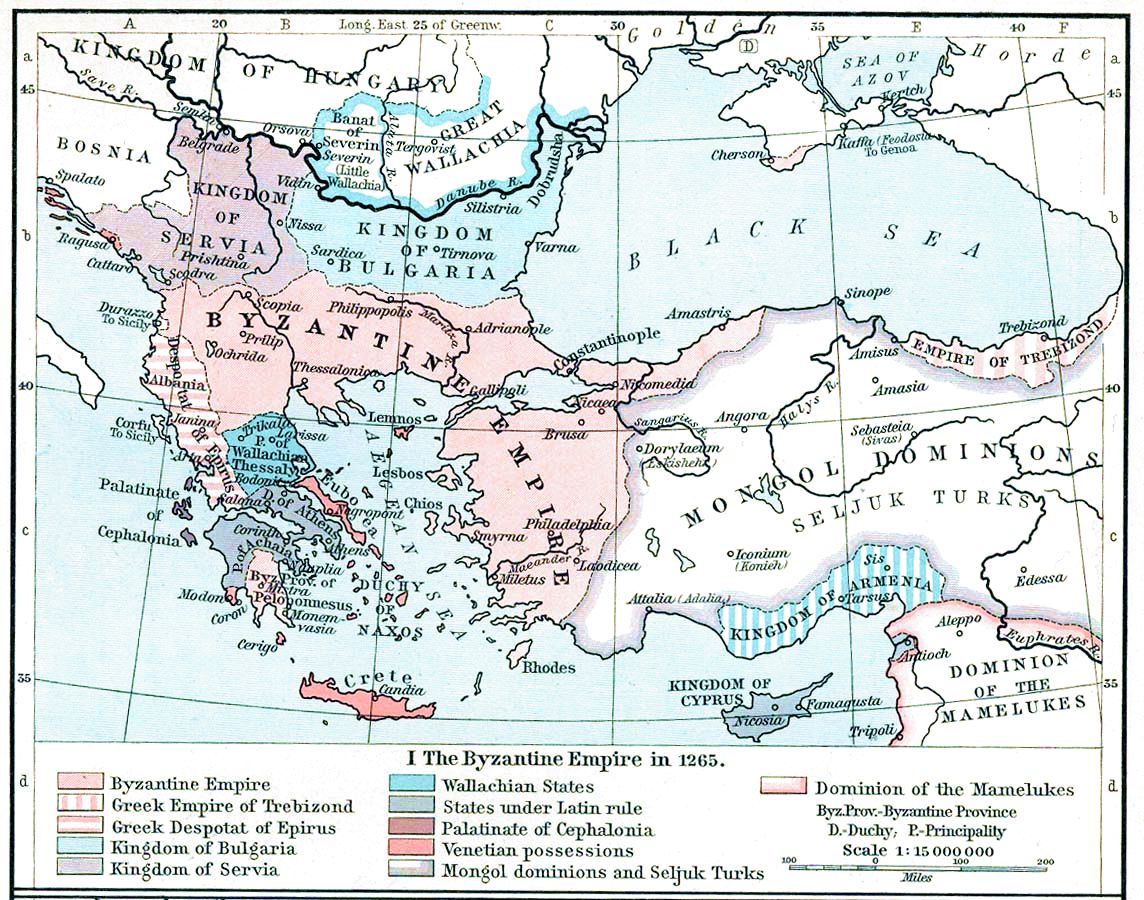
| Danasîn | Map, The Byzantine Empire, 1265. | ||||||||||||||||||||||
| Dîrok | |||||||||||||||||||||||
| Çavkanî | The Historical Atlas, William R. Shepherd, 1911. | ||||||||||||||||||||||
| Xwedî |
|
||||||||||||||||||||||
| Guhartoyên din |
Derivative works of this file: |
||||||||||||||||||||||

|
This old map image could be re-created using vector graphics as an SVG file. This has several advantages; see Commons:Media for cleanup for more information. If an SVG form of this image is available, please upload it and afterwards replace this template with
{{vector version available|new image name}}.
It is recommended to name the SVG file “ShepherdByzempire1265.svg”—then the template Vector version available (or Vva) does not need the new image name parameter. |


Lîsans
|
This work is in the public domain in its country of origin and other countries and areas where the copyright term is the author's life plus 70 years or fewer.
| |
| This file has been identified as being free of known restrictions under copyright law, including all related and neighboring rights. | |
This media file is in the public domain in the United States. This applies to U.S. works where the copyright has expired, often because its first publication occurred prior to January 1, 1929, and if not then due to lack of notice or renewal. See this page for further explanation.
|
 | |
 |
This image might not be in the public domain outside of the United States; this especially applies in the countries and areas that do not apply the rule of the shorter term for US works, such as Canada, Mainland China (not Hong Kong or Macao), Germany, Mexico, and Switzerland. The creator and year of publication are essential information and must be provided. See Wikipedia:Public domain and Wikipedia:Copyrights for more details.
|
Dîroka daneyê
Ji bo dîtina guhartoya wê demê bişkoka dîrokê bitikîne.
| Dîrok/Katjimêr | Wêneyê biçûk | Mezinahî | Bikarhêner | Şirove | |
|---|---|---|---|---|---|
| niha | 15:28, 16 çiriya paşîn 2022 | | 1144 x 900 (281 KB) | Gyalu22 | Reverted to version as of 16:26, 12 July 2009 (UTC) |
| 14:49, 20 gulan 2016 |  | 1144 x 900 (858 KB) | Julieta39 | Cosmetic (see discussion file) | |
| 16:26, 12 tîrmeh 2009 |  | 1144 x 900 (281 KB) | Alex:D | whitened | |
| 16:17, 12 tîrmeh 2009 |  | 1144 x 900 (281 KB) | Alex:D | whitened | |
| 16:12, 12 tîrmeh 2009 |  | 1144 x 900 (281 KB) | Alex:D | whitened | |
| 13:40, 21 kanûna pêşîn 2004 |  | 1144 x 900 (272 KB) | Mschlindwein | Map, The Byzantine Empire, 1265. The Historical Atlas, William R. Shepherd, 1911. |
Bikaranîna pelê
Rûpelekî ku ji vê dosyeyê bi kar tîne nîne.
Bikaranîna gerdûnî ya pelê
Ev wîkiyên di rêzê de vê pelê bi kar tînin:
- Bikaranîna di an.wikipedia.org de
- Bikaranîna di ar.wikipedia.org de
- Bikaranîna di azb.wikipedia.org de
- Bikaranîna di az.wikipedia.org de
- Bikaranîna di be-tarask.wikipedia.org de
- Bikaranîna di be.wikipedia.org de
- Bikaranîna di bg.wikipedia.org de
- Bikaranîna di ca.wikipedia.org de
- Bikaranîna di cs.wikipedia.org de
- Bikaranîna di de.wikipedia.org de
- Bikaranîna di el.wikipedia.org de
- Bikaranîna di en.wikipedia.org de
Zêdetir bikaranîna global a vê pelê bibîne.