
Wêne:Strait of Gibraltar perspective.jpg

Mezinahiya vê pêşdîtinê: 800 × 480 pîksel. Resolusyonên din: 320 × 192 pîksel | 1024 × 615 pîksel | 1528 × 917 pîksel.
Dosyeya orjînal (1528 × 917 pixel, mezinbûnê data: 182 KB, MIME-typ: image/jpeg)
| Ev pel ji Wikimedia Commonsê ye. Agahdariya li ser rûpela danasîna pelê li jêr tê nîşandan. |
Danasîn
| Danasîn |
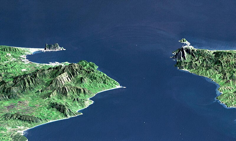
English: "This perspective view shows the Strait of Gibraltar, which is the entrance to the Mediterranean Sea from the Atlantic Ocean, with a 3-times vertical exaggeration to enhance topographic expression. Europe (Spain) is on the left. Africa (Morocco) is on the right. The Rock of Gibraltar, administered by Great Britain, is the peninsula in the back left." (quotation taken from the more detailed NASA description page)
Deutsch: Straße von Gibraltar; Aufnahme der NASA dreifach überhöht. Erstellt aus Daten von SRTM und Landsat
Français : Vue en perspective du détroit de Gibraltar ouvrant sur la mer Mediterranée avec le Maroc à droite et l'Espagne a gauche. coté espagnol on remarque le rocher de Gibraltar, en face le petit rocher est Ceuta, territoire espagnol en terre africaine.
Español: Peñón de Gibraltar |
| Dîrok |
|
| Çavkanî | http://photojournal.jpl.nasa.gov/catalog/PIA03397 |
| Xwedî | NASA / JPL / NIMA |
| Guhartoyên din |
Derivative works of this file: |
Lîsans
| This file is in the public domain in the United States because it was solely created by NASA. NASA copyright policy states that "NASA material is not protected by copyright unless noted". (See Template:PD-USGov, NASA copyright policy page or JPL Image Use Policy.) | ||
 |
Warnings:
|
| Annotations | This image is annotated: View the annotations at Commons |
Dîroka daneyê
Ji bo dîtina guhartoya wê demê bişkoka dîrokê bitikîne.
| Dîrok/Katjimêr | Wêneyê biçûk | Mezinahî | Bikarhêner | Şirove | |
|---|---|---|---|---|---|
| niha | 00:20, 14 çiriya paşîn 2005 | | 1528 x 917 (182 KB) | Oxam Hartog | en : Perspective view from the Strait of Gibraltar, Marocco is on rigth, Spain on left with the Rock of Gibraltar ahead on left. On the other side the little rock is Ceuta Spain territory on african continent fr: Vue en perspective du detroit de Gibaltar |
Bikaranîna pelê
Rûpelekî ku ji vê dosyeyê bi kar tîne nîne.
Bikaranîna gerdûnî ya pelê
Ev wîkiyên di rêzê de vê pelê bi kar tînin:
- Bikaranîna di af.wikipedia.org de
- Bikaranîna di ar.wikipedia.org de
- Bikaranîna di azb.wikipedia.org de
- Bikaranîna di az.wikipedia.org de
- Bikaranîna di be.wikipedia.org de
- Bikaranîna di bo.wikipedia.org de
- Bikaranîna di br.wikipedia.org de
- Bikaranîna di bs.wikipedia.org de
- Bikaranîna di ca.wikipedia.org de
- Bikaranîna di ckb.wikipedia.org de
- Bikaranîna di de.wikipedia.org de
- Bikaranîna di de.wiktionary.org de
- Bikaranîna di en.wikipedia.org de
- Bikaranîna di en.wikivoyage.org de
- Bikaranîna di es.wikipedia.org de
- Bikaranîna di et.wikipedia.org de
- Bikaranîna di frr.wikipedia.org de
- Bikaranîna di fr.wikipedia.org de
- Bikaranîna di ja.wikipedia.org de
- Bikaranîna di ka.wikipedia.org de
- Bikaranîna di kbd.wikipedia.org de
- Bikaranîna di ky.wikipedia.org de
- Bikaranîna di lt.wikipedia.org de
- Bikaranîna di mt.wikipedia.org de
- Bikaranîna di nl.wikipedia.org de
- Bikaranîna di pl.wiktionary.org de
- Bikaranîna di pt.wikipedia.org de
- Bikaranîna di ro.wikipedia.org de
- Bikaranîna di ru.wikipedia.org de
- Bikaranîna di ru.wiktionary.org de
- Bikaranîna di sl.wikipedia.org de
- Bikaranîna di sw.wikipedia.org de
- Bikaranîna di uk.wikipedia.org de
- Bikaranîna di uz.wikipedia.org de
Zêdetir bikaranîna global a vê pelê bibîne.