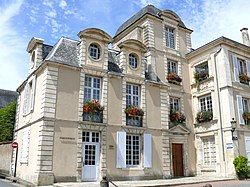
Saint-Maixent-l'École
Xuyakirin
Saint-Maixent-l'École | |
|---|---|
Komun | |
| Saint-Maixent-l'École | |
 Dîmenek ji komunê | |
Saint-Maixent-l'École li ser nexşeyê | |
| Koordînat: 46°24′46″Bk 0°12′29″Ra / 46.41278°Bk 0.20806°Ra | |
| Dewlet | Fransa |
| Li beşa îdarî | |
| Paytexta | |
| Qada rûerdê | |
| • Giştî | 5.22 km2 (202 sq mi) |
| Bilindahî | 74 m (243 ft) |
| Nifûs | 7433 (2022) |
| Malper | www |
| biguhêre - Wîkîdaneyê biguhêre | |
Saint-Maixent-l'École komuneke departmena Deux-Sèvres a li herêma Nouvelle-Aquitaine e ku yek ji komunên rojavayê Fransayê ye.[1]
Nifûs
[biguhêre | çavkaniyê biguhêre]| Sal | Nifûs | ±% |
|---|---|---|
| 1780 | 3980 | — |
| 1901 | 4870 | +22,4% |
| 2006 | 7832 | +60,8% |
| 2015 | 6523 | −16,7% |
| 2016 | 6919 | +6,1% |
| 2017 | 6982 | +0,9% |
| 2018 | 7209 | +3,3% |
| 2019 | 7242 | +0,5% |
| 2020 | 7243 | +0,0% |
| 2021 | 7254 | +0,2% |
| 2022 | 7433 | +2,5% |
| Çavkanî: Li ser Wîkîdaneyê bibîne | ||
Mijarên têkildar
[biguhêre | çavkaniyê biguhêre]Çavkanî
[biguhêre | çavkaniyê biguhêre]- ^ "Résultats de la recherche | Insee". www.insee.fr. Roja gihiştinê 11 çiriya paşîn 2024.
Girêdanên derve
[biguhêre | çavkaniyê biguhêre]| Ev gotara têkildarê erdnîgariya Fransayê şitlekê ye. Heke tu bixwazî berfireh bikî pê li biguhêre bike. (Çawa?) |


