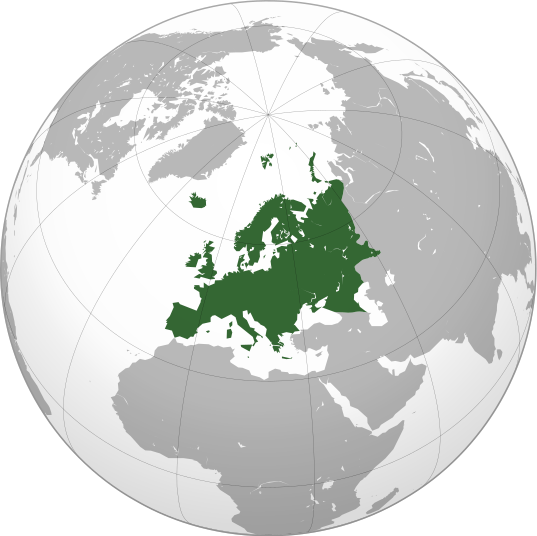
Wêne:Europe orthographic Caucasus Urals boundary.svg

Size of this PNG preview of this SVG file: 537 × 536 pîksel. Resolusyonên din: 240 × 240 pîksel | 481 × 480 pîksel | 769 × 768 pîksel | 1026 × 1024 pîksel | 2052 × 2048 pîksel.
Dosyeya orjînal (Daneya SVG, mezinbûna rast: 537 × 536 pixel; mezinbûna daneyê: 77 KB)
Dîroka daneyê
Ji bo dîtina guhartoya wê demê bişkoka dîrokê bitikîne.
| Dîrok/Katjimêr | Wêneyê biçûk | Mezinahî | Bikarhêner | Şirove | |
|---|---|---|---|---|---|
| niha | 13:32, 4 îlon 2022 |  | 537 x 536 (77 KB) | M.Bitton | Reverted to version as of 12:03, 4 September 2022 (UTC): per COM:OVERWRITE |
| 13:30, 4 îlon 2022 |  | 537 x 536 (177 KB) | Рагин1987 | Small correction | |
| 12:03, 4 îlon 2022 |  | 537 x 536 (77 KB) | M.Bitton | Reverted to version as of 05:48, 12 March 2019 (UTC): per COM:OVERWRITE + fake svg | |
| 19:12, 30 tebax 2022 |  | 2052 x 2048 (874 KB) | Рагин1987 | More correct visualization of the dividing line on the territory of the Caucasus Range | |
| 05:48, 12 adar 2019 |  | 537 x 536 (77 KB) | AndreyKva | Optimized. | |
| 19:25, 3 adar 2016 |  | 537 x 536 (197 KB) | Denniss | Reverted to version as of 13:27, 19 October 2014 (UTC) | |
| 18:37, 3 adar 2016 |  | 537 x 536 (239 KB) | Ercwlff | UC UC UC | |
| 13:27, 19 çiriya pêşîn 2014 |  | 537 x 536 (197 KB) | Deni Mataev | Again, The entirety of Georgia is not in Europe geographically, only North Eastern parts are | |
| 20:05, 18 çiriya pêşîn 2014 |  | 537 x 536 (238 KB) | Politologia | Reverted to version as of 10:57, 18 October 2014 In all maps Georgia is part of Georgia. There is at list 10 versions of borders of Europe in most of them Georgia is part of Europa | |
| 20:04, 18 çiriya pêşîn 2014 |  | 537 x 536 (238 KB) | Politologia | Reverted to version as of 10:57, 18 October 2014 In all maps Georgia is part of Georgia. |
Bikaranîna pelê
Ev 74 rûpel li jêr vê dosyeyê bi kar tînin:
- Afrîka
- Albanya
- Almanya
- Amerîka (parzemîn)
- Amerîkaya Bakur
- Amerîkaya Başûr
- Andorra
- Antarktîka
- Asya
- Awistirya
- Awistralya (parzemîn)
- Azerbaycan
- Bakurê Kîprosê
- Başûrê Alanistanê
- Belarûs
- Belçîka
- Bosniya û Herzegovîna
- Bulgaristan
- Danîmarka
- Ebxazya
- Ermenistan
- Estonya
- Ewrasya
- Ewropa
- Fransa
- Fînlenda
- Gondwana
- Gurcistan
- Holenda
- Keyaniya Yekbûyî
- Komara Artsax
- Komara Îrlendayê
- Kosova
- Kroatya
- Kîpros
- Lawrasya
- Letonya
- Liechtenstein
- Lîtvanya
- Lûksembûrg
- Makedonyaya Bakur
- Malta
- Mecaristan
- Moldova
- Monako
- Montenegro
- Norwêc
- Okyanûsya
- Pangea
- Parzemîn
- Polonya
- Portûgal
- Qazaxistan
- Romanya
- Rûsya
- San Marîno
- Serbistan
- Slovakya
- Slovenya
- Spanya
- Swêd
- Swîsre
- Tirkiye
- Transnîstriya
- Vatîkan
- Yewnanistan
- Çekya
- Îslenda
- Îtalya
- Ûkrayna
- Bikarhêner:Baran Agir/Awistirya
- Şablon:Dewletên Ewropayê
- Şablon:Parzemîn
- Kategorî:Parzemîn
Bikaranîna gerdûnî ya pelê
Ev wîkiyên di rêzê de vê pelê bi kar tînin:
- Bikaranîna di ab.wikipedia.org de
- Bikaranîna di ace.wikipedia.org de
- Bikaranîna di ady.wikipedia.org de
- Bikaranîna di af.wikipedia.org de
- Bikaranîna di ar.wikipedia.org de
- بوابة:آسيا
- بوابة:أوروبا
- بوابة:إفريقيا
- بوابة:القارة القطبية الجنوبية
- بوابة:القارة القطبية الجنوبية/بوابات شقيقة
- قائمة جوازات السفر
- بوابة:تركيا
- بوابة:تركيا/بوابات شقيقة
- بوابة:جغرافيا/مقالة مختارة/أرشيف
- المرأة في تركيا
- بوابة:أوروبا/واجهة
- بوابة:تصفح
- بوابة:تصفح/جغرافيا
- قائمة مفاتيح الاتصال الدولية
- المرأة في ألمانيا
- بوابة:إسطنبول
- بوابة:آسيا/بوابات شقيقة
- ويكيبيديا:مقالة الصفحة الرئيسية المختارة/398
- بوابة:جغرافيا/مقالة مختارة/21
- معاملة المثليين في أوروبا
- المرأة في أوروبا
- المرأة في البرتغال
- المرأة في فنلندا
- المرأة في مقدونيا الشمالية
- المرأة في ترانسنيستريا
- المرأة في الفاتيكان
- المرأة في أذربيجان
- المرأة في اليونان
- المرأة في ألبانيا
- المرأة في إيطاليا
- المرأة في الجبل الأسود
Zêdetir bikaranîna global a vê pelê bibîne.


